THE CITY CENTREAREAS OF DUBLIN
I PROMISED TO REVISITMY SECOND VISIT TO THE NEW PUBLIC PARK ON BRIDGEFOOT STREET
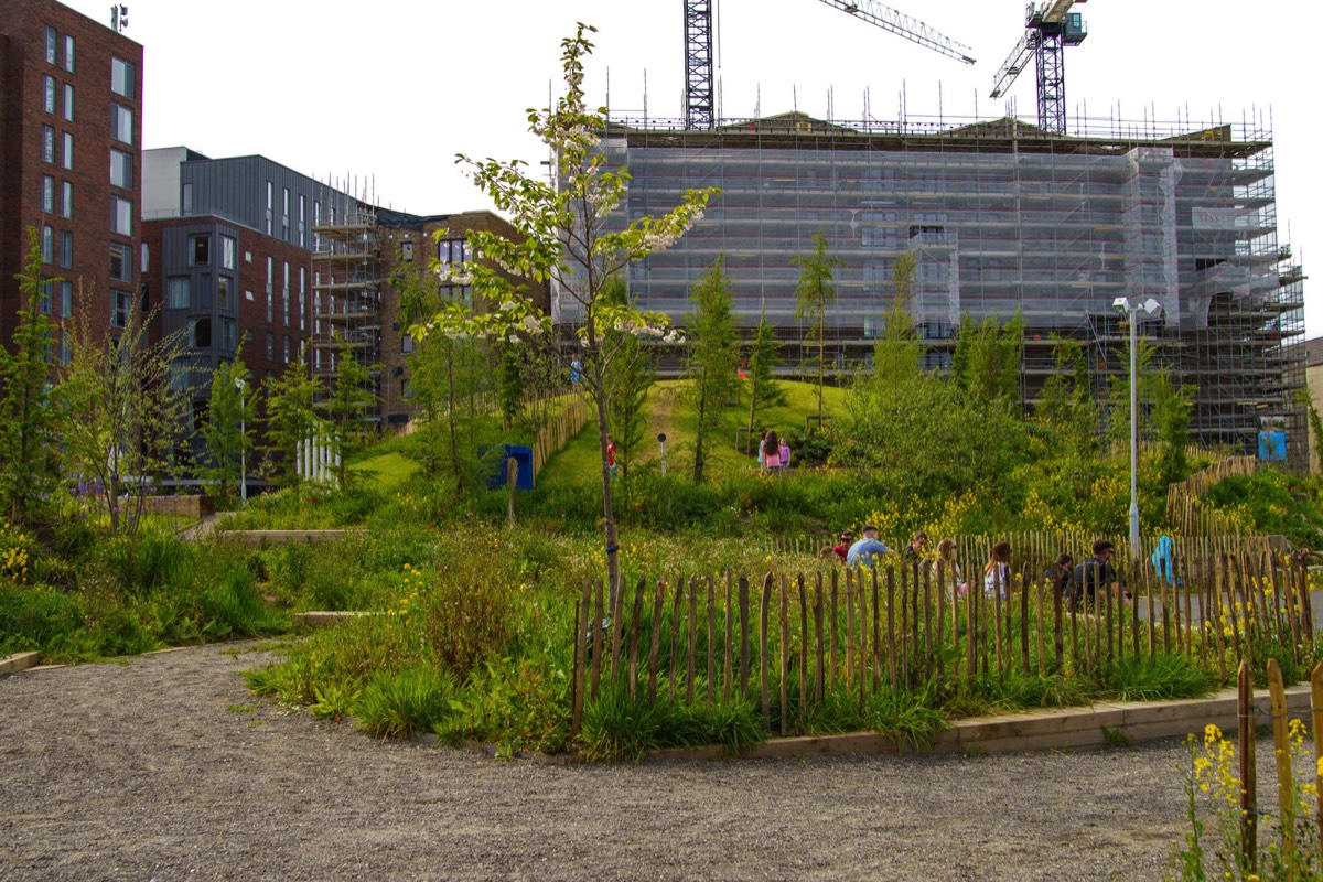
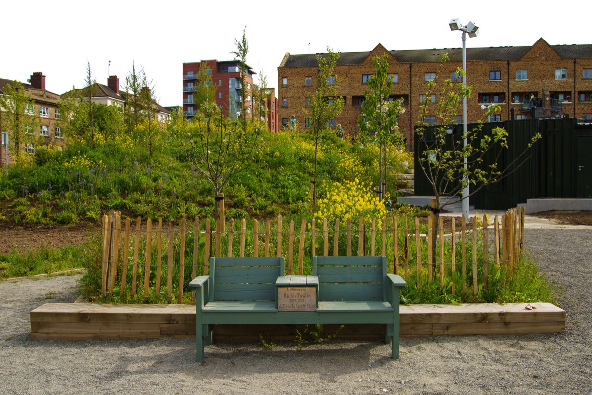
NEW PUBLIC PARK ON BRIDGEFOOT STREETOPENED 4 MAY 2022
URBAN EXPRESSION ALONG LIBERTY LANEST PATRICK'S DAY 2022
This laneway was unusually busy today as people used it as a short cut or in order to avoid the crowds lining the streets because of the St. Patrick's Day parade.
In the past I described this as a laneway at the side of Kevin Street College but as the building has been demolished this is no longer a valid description as the. In fact, as I only discovered a few months ago, it was never an accurate description because South Church Lane is the the laneway that was at the side of the college.

EAST ROAD FROM UPPER SHERIFF STREET TO CHURCH ROAD
I was a bit disappointed with these images as they were underexposed and any attempted corrections introduced lots of noise so I plan to revisit the East Wall area and photograph the area again later in the year.
East Wall dates from the end of the eighteenth century from the time of the construction of the North Wall. It was originally a working-class area, with many finding employment in Dublin Port, adjacent to the area.

OSSORY ROAD NORTH STRAND AREA OF DUBLIN
This is an old industrial area in the docklands and was once home to Cadburys and many other companies.
Cadburys chocolate was founded in Birmingham in the 1830’s. It was a century later when the company opened its first Irish factory in 1933 on the Ossory Road. Three of the company’s products were made here, including their famous Dairy Milk bars. In 1939 they opened a second Dublin factory, on the East Wall Road.
The premises on the East Wall Road had been built eight years earlier (in 1931) for the Gallaher tobacco group, and named Virginia House. Once acquired by Fry Cadbury it was renamed Alexandra House. In 1964 the current Cadburys factory in Coolock opened, which saw the demise of the East Wall operation. The building was taken over by Wiggins Teape and renamed Gateway House . In 2001 Gateway house was demolished by Collen Bros.
Osraige (Old Irish) or Osraighe (Classical Irish), Osraí (Modern Irish), anglicised as Ossory, was a medieval Irish kingdom comprising what is now County Kilkenny and western County Laois, corresponding to the Diocese of Ossory. The home of the Osraige people, it existed from around the first century until the Norman invasion of Ireland in the 12th century. It was ruled by the Dál Birn dynasty, whose medieval descendants assumed the surname Mac Giolla Phádraig.

MEATH PLACEOFF MEATH STREET
It was a very wet windy day when I visited the area.
Meath Place is a short street off Meath Street. There are some modern apartments at the Meath Street end and then the street is mostly made up of small cottages and one or two industrial buildings. Meath Street is a great street for shopping, one of the last market streets left in Dublin, it has the Liberty Market, A great selection of Butchers Shops, Green Grocers and cafes.

NORTH WALL QUAYTHE POINT DEPOT END

THE FOUR MASTERS PARKWHY IS THERE NO PUBLIC ACCESS
I have never been able to gain access to this park and I waited until I knew more about this park before publishing these photographs which date from the 16th. April 2021. I also had problems processing the photographs as there was excessive lens flare.
Not long after I visited it was reported that local residents have demanded to know why a religious order which uses public resources to maintain a park in Dublin city centre has refuse to open the grounds to the public.
The Four Masters Park in front of the Mater Hospital in Dublin 7 is owned by the Sisters of Mercy. However, Dublin City Council maintains and landscapes the green area. Despite public money being used for the upkeep of the grounds, the gates of the park are padlocked shut.
The park commemorates the Annals of the Four Masters and it features a high cross memorial which was commissioned by Sir William Wilde and executed by James Cahill. Many accounts indicate that the high cross was given by the Sisters of Mercy for the benefit of the local community which does not make a lot of sense if the park is closed to the public.
Apparently there was a plan for a new Metro Service to use much of the park for access to a new railway station which was built under the nearby Mater Hospital. €20 million was spent on installing a station box beneath a new section of the hospital. The Metro North enabling works were completed in 2013 under the Mater Whitty Building by BAM Contractors Ltd on behalf of the Railway Procurement Agency.

BENBURB STREETPHOTOGRAPHED FEBRUARY 2022
Benburb Street runs parallel with the River Liffey from Queen Street to Parkgate Street, running along the southern side of Collins Barracks. The LUAS red line runs along the street.
The street was originally named as Barrack Street as it was close to the former Royal Barracks. The section closest to Queen Street was known as Tighe Street, but previously known as the Gravel Walk up to circa 1780. Both streets were amalgamated and renamed Benburb Street in 1890. It was named for the Battle of Benburb in County Armagh in 1646.
Historically, the street was associated with sex work due to its proximity to Collins Barracks. This association continued up until the late 1990s.

CHANCERY PLACE AND CHANCERY HOUSEPHOTOGRAPHED FEBRUARY 2022
The Dublin Christian Mission is located at Chancery Place. it serves as a Christian community centre for a variety of different ministry opportunities. Some of the opportunities include youth clubs, community events, Cafe, small groups, transitional housing, short-term teams, food pantry and office space.
For me the most interesting thing about Chancery Place is the Chancery Place Flats [Chancery House] complex which was designed by Herbert G. Simms.
The Chancery Park flats have been described as, "a small carefully conceived building containing 27 flats with an adjoining enclosed garden which was completed in 1935." A plaque on the gateway to the complex is dedicated to Herbert Simms who was appointed Housing Architect for the city of Dublin in 1932. Herbert George Simms, died September 28 1948.
Until 1932 new housing in Dublin had been the responsibility of the city architect, Horace O'Rourke. Between 1923 and 1931 new dwellings were being erected at an average rate of 555 per annum, but the shortage of adequate housing in the city remained acute. In 1932 or 1933 a separate housing architect's Department was formed with specific responsibility for the design and erection of new dwellings, as distinct from their administration and maintenance. Simms was appointed to the new post of Corporation housing architect. He immediately recruited a temporary staff to assist him in the task which confronted him. In 1935 alone 1,552 dwellings were completed. During the sixteen years he was in office, Simms was responsible for the design and erection of some 17,000 new homes, ranging from striking blocks of flats in the central city [influenced by new apartment blocks by de Klerk in Amsterdam and J.P. Oud in Rotterdam] to extensive suburban housing schemes such as those at Crumlin and Cabra.

AMY AUSTIN DRURY STREET
When I first saw this in 2021 I thought that it was an example of street art.
I have been advised by a friend that the name "Amy Austin" is a reference to a graffiti message, "I Love You So Much mural, by Austin [Texas] based musician Amy Cook.
The wine bar within a car park sits thirty guests and according my, already mentioned, friend it has a single large table in the middle with bar seating at the walls.

DRURY STREETFEBRUARY 2022
Drury Street was originally known as Little Boater Lane before it became Drury Lane before becoming a street. According to a number of local historians Drury is a reference to Sir William Drury who had been Lord Justice of Ireland in the late 16th Century. Today the street is a shopping destination but more recently it has become a popular dining destination.
Sir William Drury (2 October 1527 – 13 October 1579) was an English statesman and soldier. In 1576, he was sent to Ireland as President of Munster, where his rule was severe but effective, and in 1578 he became Lord Justice of Ireland, taking the chief control of affairs after the departure of Sir Henry Sidney.
He was engaged in resisting the rebellion of the Earl of Desmond in the summer of 1579 when he died of illness at Waterford in Oct. He was buried in St. Patrick's Cathedral. A monument bearing his effigy was erected some time later, but no longer exists. His house in London gave its name to the street Drury Lane.

SOUTH WILLIAM STREETDUBLIN CITY CENTRE
Someone mentioned to me that there are currently seventeen restaurants on South William Street ... some day I might go to the trouble of checking this claim.
South William Street, laid out in 1676 by William Williams, was part of the expansion of Dublin in the 17th century as the city outgrew the medieval walls. The street became a prominent area of the city in the 18th century and what can be seen today is mainly a legacy from that era. Today, the street has one of the largest and most complete groups of 18th century merchants' houses in Dublin.

THE WB YEATS STATUE IN ST STEPHEN'S GREEN BY HENRY MOORE
The Yeats memorial garden with a sculpture by Henry Moore.
Published on 8 July 2020: "Today, the Office of Public Works is delighted to announce the reopening of the William Butler Yeats Memorial in St Stephens Green Park, following an extensive programme of conservation works including the rejuvenation of ‘Knife Edge’ a sculpture by the internationally renowned sculpture Henry Moore."
The W.B. Yeats Memorial is situated in an area known as the “Mount”, being a series of irregular terraces, forming an amphitheatre within the park. The creation of the amphitheatre was intentional; to provide an area in the Green that can be used for quiet contemplation or theatre, in the round and oration, reflecting Yeats’ work as a poet & playwright, as much as an informal place for people to gather. It remains today a much loved place, regarded by many as their own shared secret place among the trees.
The sculpture was donated by the W.B. Yeats Memorial Committee and funded by Irish American Philanthropist Mr. J. Kelly and Córas Tráchtála Teoranta. The Committee, who made a formal application to the Office of Public Works to place the proposed memorial in St Stephens Green, as "it was one of Yeats' favourite haunts."
The location of the sculpture was specifically chosen for the attractive views of the lake and waterfall obtained from the setting, which was terraced and paved by the Office of Public Works at the time. It has been cited as one of the finest settings for Henry Moore's 'Knife Edge' by such eminent bodies as the Henry Moore Foundation.
Set onto the terrace in front of the sculpture is a plaque giving the sculpture its context as part of the Memorial. This was created by esteemed Sculptor Michael Biggs, the prominent sculptor and graphic designer responsible for the Arbour Hill Memorial Wall and the Series B Irish Banknotes (circulation 1976-1992).
On October 26th 1967, the W.B. Yeats Memorial was unveiled by the Taoiseach, Mr. Jack Lynch. The recent works included; repair and re-laying of pavements, steps and terraces; conservation of bronze sculpture and plaque; and installation of handrails to improve accessibility to the W.B. Yeats Memorial.

THE HAIRY LEMONWHAT A STRANGE NAME FOR A PUB
In Dublin in the 1950s there was a dog catcher and he had a lemon shaped head and yellowish skin and therefore the locals referred to him as the hairy lemon.
Situated on Johnsons Place, close to the Stephens Green Centre and Grafton Street, the Hairy Lemon provides a welcome atmosphere as you take a break from the city or settle in for a pleasant drink in good company.

CASTLEMARKETMANY UPSET BY NEW SURFACE
Many are complaining, especially online, about Dublin City Council's decision to remove the iconic red cobblestones [red brick pavers] from Castle Market so I decided to have a look.
Dublin City Council issued the following statement "There has been significant deterioration in the condition of the red brick pavers currently on Castlemarket due to constant loading from delivery trucks. This significant deterioration has caused bricks to loosen which has resulted in numerous trip hazards and an unsuitable surface for pedestrians. Road Maintenance Services’ contractor, SIAC BP, are replacing the area of red brick pavers with a beige coloured asphalt which is more pedestrian friendly while also being able to sustain the loading from delivery trucks. The beige colour is in keeping with other recent pedestrian area resurfacing around the city including Exchequer Street, Wicklow Street, Duke Street, South Anne Street and North Earl Street."

THE TIGER AND THE LUCKY DUCKAUNGIER STREET
The Tiger Mural predates the current Year Of The Tiger [Lunar New Year].
The owners describe the Lucky Duck as " an elegant neighbourhood pub and cocktails bar where we are making the old new again."
The building, dating from 1890 and is was at one stage known as Aungier House, has been vacant for at least twenty years and while I went to Kevin Street College, nearby, I cannot remember the name that it operated under but according to some of my fellow students it sold the cheapest pint in Dublin (I never knew if that was a recommendation or a warning).
I am not an expert when it comes to Dublin Pubs but to the best of my knowledge The Lucky Duck was originally to be called The Dutch Billy, after an architectural style of building that was once common in Dublin but when it was realised that the name might be considered to be a reference to William of Orange that idea was dropped.
Note: Dublin’s Dutch Billys [Gable fronted houses] were reputedly named after William of Orange, and their arrival in Dublin is generally attributed to an influx of French Huguenots after 1685 and to Dutch and Flemish Protestants fleeing persecution after 1690.
I would have gone with Dutch Billy.

DONORE AVENUESOUTH CIRCULAR TO CORK STREET
Even though it connects the South Circular to Cork Street, two areas that I visit at regular intervals, this was only my third time to visit Donore Avenue and there is still a lot of urban depression and decay to be seen especially towards the Cork Street end.
The “Margaret Kennedy Road and Court” development now provides 54 new homes consisting of 38 houses and 16 apartments and is the first phase of the overall Framework Development Plan for the regeneration of St Teresa’s Gardens.
Once one of the city’s largest council flat complexes, St Teresa’s Gardens, on Donore Avenue, was earmarked for regeneration in 2005, but the plan was scrapped in 2009 after the collapse of the property market.
Recently it was announced that plans to build a 22-storey tower have been scaled back following local opposition to the size and height of the planned development. The redesign of the development at the site of the St Teresa’s Gardens flat complex will result in about about one hundred fewer homes.
According to reports in local media the total number of homes expected to be delivered has been reduced from 700 to about 540.

SOUTH BROWN STREETAND BRICKFIELD LANE
The Cork Street Fever Hospital was built on a site, known as "Widow Donnelly’s Orchard" , The site was bound by Love Lane (now Donore Avenue) to the west and Brickfield Lane to the east.
The Mercy Family Centre is located in an old school building in South Brown Street, opposite Saint Theresa's Gardens, an area where isolation, poverty and drugs are common. The Centre provides direct innovative programmes that help children, families and individuals to work together to be their very best.They are committed to providing the highest quality childcare, early education, adult education and social service solutions.
The original hospital, which was located in a poor densely populated part of the Liberties but with large grounds, was designed by Samuel Johnston and built by Henry, Mullins & McMahon. It consisted of two parallel brick buildings, 80 by 30 feet (24.4 by 9.1 m), three stories high, connected by a colonnade of 116 feet (35 m). The eastern range was used for fever, the western for convalescent patients, in order to keep the patients separated. It opened on 14 May 1804. The objectives of the hospital were to care for the diseased in the neighbourhood and prevent the spread of infection in the homes of the poor.
An additional building, much larger than any of the former, was added in 1814, by which the hospital was rendered capable of containing 240 beds.
The hospital initially accepted fever patients from five parishes in the Liberties. A year after its foundation the catchment area was extended to the district south of the River Liffey as far as the South Circular Road. By 1810 this was extended to the whole of the city of Dublin, and to all classes of applicants, which increased the financial pressure on the hospital. In the year 1812 over 2,200 patients were admitted. The hospital did succeed in checking the spread of disease, but the worsening unemployment in the Liberties following the Act of Union and occasional epidemics, such as Scarlet fever, pushed up the mortality rate for the first few years of its existence. However, by 1815 the mortality rate in the hospital had declined to 1 in 20 (from 1 in 11 in 1804).
Dublin had six typhus epidemics in the 18th century – it was not at the time known that typhus was caused by a louse-born organism, which flourished in unhygienic conditions. The hospital was extended between 1817 and 1819 to help cope with a national epidemic. Three thousand cases were admitted to the hospital in one month in 1818.
Another typhus epidemic hit Dublin in 1826. In the hospital, 10,000 people were treated for the infection. It was so overcrowded that tents were erected in the grounds (fortunately, over 4 acres (1.6 ha) acres in extent), and these provided 400 extra beds. In 1832 Dublin was ravaged by a cholera epidemic. Despite the best efforts of all concerned, thousands of victims died and were hastily buried in nearby Bully's Acre.
Typhus came again at the time of the Irish Famine in the late 1840s. During 1847 nearly 12,000 cases applied during a period of about ten months, although "amongst the poor at their own houses, .. vast numbers remained there, who either could not be accommodated in hospital, or who never thought of applying". Typhus returned in the 1880s, when Gerard Manley Hopkins died of the disease in Dublin.
In 1903 the James Weir Home for Nurses was erected on the opposite side of the street to provide accommodation for up to 50 fever nurses working at the Fever Hospital.
After services were transferred to the Cherry Orchard Hospital in Ballyfermot, the old Cork Street Fever Hospital closed in November 1953. The old hospital was renamed Brú Chaoimhín and converted into a nursing home.

CORK STREETIN THE COOMBE - FEBRUARY 2022
The sunlight was a bit overpowering so I had difficulty using my day old Voigtlander 65mm lens as it is a manual lens.
The street shown in my photographs was named after the first Earl of Cork and once formed part of the ancient highway "An Slighe Dála" connecting Dublin with the west of Ireland. On old maps it was described as "The Highway to Dolfynesberne" (i.e., Dolphin's Barn).
The street was once a centre of fine wool and silk hand-loom weaving. The woollen industry was killed off around 1700 by the English government, who wanted to keep the wool monopoly in England, although a minor revival was started around 1775. Despite problems, silk spinning and the manufacture of poplin, supported by the Royal Dublin Society, continued into the 19th century.
The Tenter House was erected in 1815 in this street, financed by Thomas Pleasants. Before this the poor weavers of the Liberties had either to suspend work in rainy weather or use the alehouse fire and thus were (as Wright expresses it) "exposed to great distress, and not unfrequently reduced either to the hospital or the gaol." The Tenter House was a brick building 275 feet long, 3 stories high, and with a central cupola. It had a form of central heating powered by four furnaces, and provided a place for weavers to stretch their material in bad weather.
In 1861 a Carmelite priest bought the Tenter House and opened it as a refuge for the homeless. He ran the hostel for ten years until 1871 when the Sisters of Mercy came to Cork Street. In 1873 they built a convent and in 1874 a primary school, which closed down in 1989.
The Cork Street Fever Hospital (also known as the House of Recovery) was a hospital that opened in Cork Street on 14 May 1804. The hospital was extended in 1817-1819 to help cope with a national typhus epidemic. In 1953 the Cherry Orchard Hospital in Ballyfermot replaced the old Cork Street hospital, which was renamed Brú Chaoimhín and became a nursing home.
Across the road from the hospital is the James Weir Home for nurses, built in 1903. The site had once been a Quaker burial ground.
In 1932 the Maryland housing development off Cork Street was constructed by Dublin Corporation. 1932 was a Marian year, hence the name Maryland.
The street was totally reconstructed towards the end of the 20th century. It is now a mostly residential area.

JACKIE'S BAR 40 FRANCIS STREET
90's inspired boozer now open on 40 Francis St, Dublin 8. I don't know when this actually opened its doors to the public but I do not remember seeing it before today.

THE LIBERTY BELLE33 FRANCIS STREET
There is a sculpture named the "liberty Bell" in a nearby public park and the pub is located at 33 Francis Street which is in an area known as "The Liberties".

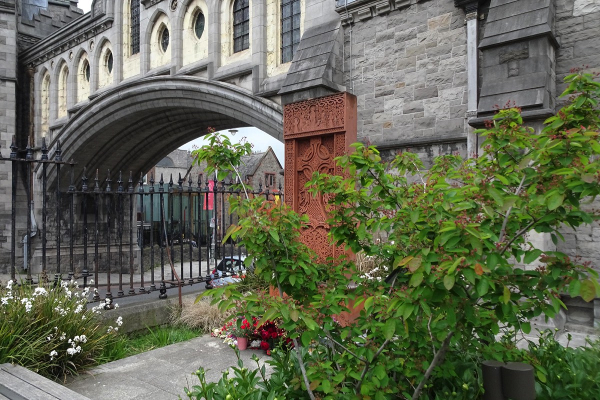
I LIKE THIS 1929 SACRED HEART SHRINEJUNCTION OF REGINALD STREET AND GRAY STREET
The inscriptions read as follows:
“Erected by the parishioners of St. Catherine’s to the glory and honour of God and in commemoration of the Centenary of the Emancipation, 1929″
“Restored to mark the visit of Pope John Paul II to the Liberties 29th Sept. 1975″
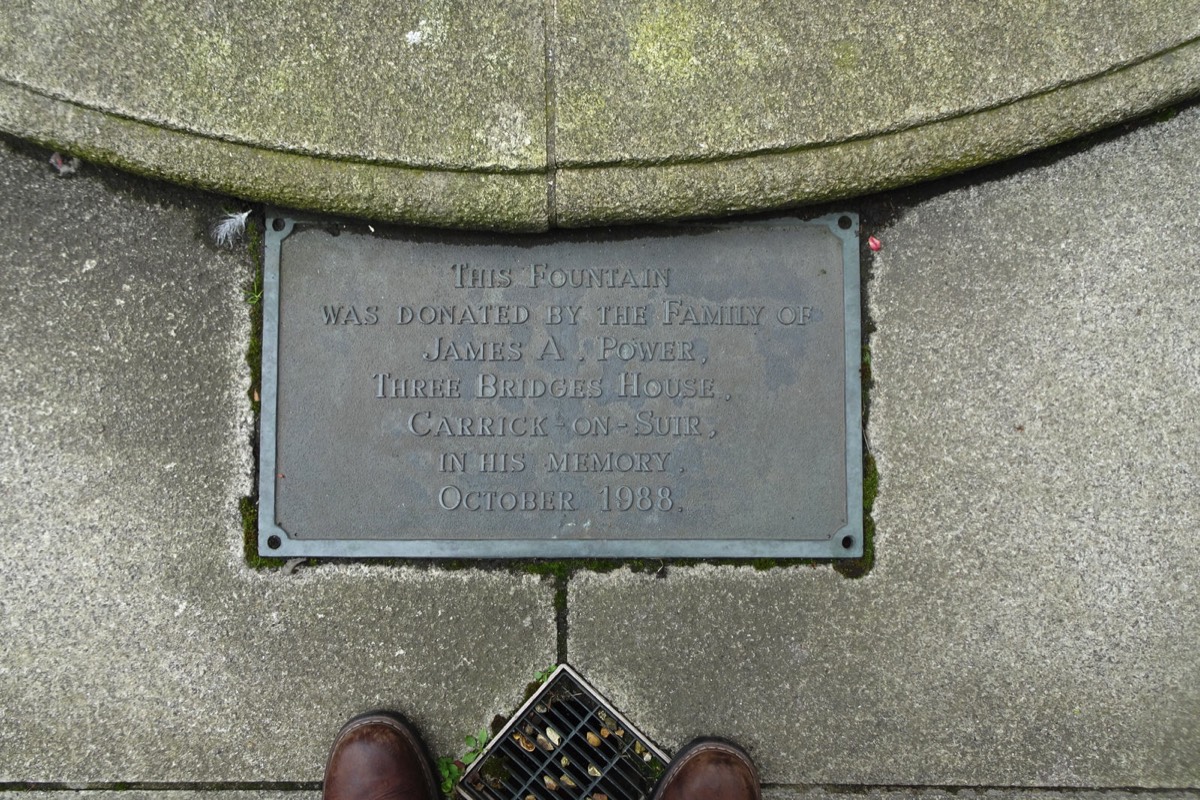
A number of memorial fountains were erected in Dublin commemorating the visit of Queen Victoria to Ireland and I must admit that my favourite is the one in Dun Laoghaire. As you may have guessed I really like these old Victorian memorial fountains
While searching, about ten or twelve years ago, for Marian Statues in Dublin I was informed by a tourist guide that there was one in the Liberties area of Dublin known as the "Holy Mary" statue.
When I eventually located it I realised that it was not a Marian Statue and that itcould have been a a Queen Victoria fountain that had been modified or converted.
After I published some photographs on Flickr I discovered that it was known at various times as "The Fountain", "The Sacred Heart Statue" or "The Catholic Emancipation Memorial".
I now know that the large canopied structure was originally built as a water fountain until the top was knocked off during the War of Independence. In 1929 the local community converted it into a Sacred Heart shrine [not a Marian Shrine] and then in 1979 it was rededicated for the Papal visit to Ireland.
According to some accounts much of the current structure is not original as the roof was replaced after the fountain had been demolished by a lorry. I do not know if the lorry accident and the War Of Independence incident were in fact the same event and to complicate the story even more some local historians maintain that pieces were shot off by British ‘Black And Tans’. To be honest, if I was the lorry driver I would have blamed someone else.

MARROWBONE LANENEAR THE GUINNESS COMPLEX
I was unaware that there was a street or laneway named George's Hill near to where I live. In fact I thought thought that it was but a section of North Anne Street and to add to my confusion I have frequently photographed the Church Of St. George on Hill Street.
The street features a former school which was but one element of a cluster of buildings accommodating a school, convent, chapel and orphanage. The school was designed by John Burke, a Dublin architect who worked on a vast body of religious buildings. Its extension was designed by W. H. Byrne. Its recent (1992) adaptation to supported housing has successfully maintained its character including the generous timber sash windows. The window openings respond to the building form by emphasising the front gables with round arches and distinguishing between ground and first floor windows. The high level of the ground floor windows is typical of nineteenth-century school buildings ensuring ample daylight within while maintaining privacy and eliminating distracting views to outside. Together this cluster of buildings have an important social significance in the local area.

GEORGE'S HILLJANUARY 2022
I was unaware that there was a street or laneway named George's Hill near to where I live. In fact I thought thought that it was but a section of North Anne Street and to add to my confusion I have frequently photographed the Church Of St. George on Hill Street.
The street features a former school which was but one element of a cluster of buildings accommodating a school, convent, chapel and orphanage. The school was designed by John Burke, a Dublin architect who worked on a vast body of religious buildings. Its extension was designed by W. H. Byrne. Its recent (1992) adaptation to supported housing has successfully maintained its character including the generous timber sash windows. The window openings respond to the building form by emphasising the front gables with round arches and distinguishing between ground and first floor windows. The high level of the ground floor windows is typical of nineteenth-century school buildings ensuring ample daylight within while maintaining privacy and eliminating distracting views to outside. Together this cluster of buildings have an important social significance in the local area.


BROADSTONE AND NEARBYNOW A TRANSPORT HUB
Unfortunately the area adjacent to the old railway station building now attracts a degree of anti-social behaviour which is a pity.
In 1845 the Royal Canal was purchased by the Midland Great Western Railway Company for £298,059 with a view to using the land alongside the canal to construct a railway line to the west of Ireland. Broadstone railway station was completed in 1850. The building was one of Dublin's six original rail termini, the others being Westland Row (now Pearse Station) Amiens Street (now Connolly Station), Kingsbridge (now Heuston Station), North Wall and Harcourt Street (now a bar and nightclub complex).
Situated at the crest of Constitution Hill directly opposite King's Inns, the station served as the terminus of the Midland Great Western Railway. Designed by John Skipton Mulvany, Broadstone Station is constructed of granite in a neo-Egyptian style.
With Galway projected to become the main port for transatlantic passenger traffic between Europe and North America, the Midland successfully competed with its rival the Great Southern and Western Railway to reach it first. A special fourth class was introduced by the Midland for poor migrants from the west going to Britain for work. The line, which branched out to serve Sligo, Westport, Achill and Clifden, was also used to transport huge numbers of cattle.
It was about this time that the majority of the houses in the area were constructed, as dwellings for workers on the railway. Most of the worker's houses were built by the Artisan's Dwelling Company, which built many similar estates in Dublin and elsewhere, and houses of this type are now frequently described as Artisan cottages, regardless of their origin.
The Great Irish Famine of the mid-19th century had caused a huge wave of emigration, and the population of Ireland was reduced from about 8 million in the 1830s to around 4 million a century later. The worst hit were the rural population of the west, precisely the market of the MGWR. There was a brief period of boom in the 1870s as the flow of people from the west peaked, but as the people left, traffic in the other direction reduced markedly. As emigration gradually came to a halt, so did the canal system.
The MGWR was never very interested in the canal business and in 1877 they were given permission by the government to close 150 yards (140 m) of the branch line and to fill in the harbour, to construct a new forecourt for the station. That removed the need for a movable pontoon bridge, and a new approach road, Western Way, was built by way of Foster Aqueduct. The harbour was no longer needed due to the construction of one larger and better situated at Spencer Dock, and was filled in to become the forecourt of Broadstone Station.
The small reservoir had been made almost redundant by the construction of a new reservoir at Vartry in 1868, and served only the Jameson Whiskey distilleries at Smithfield, until they left the city in the 1970s.
By the 1920s average annual tonnage on the Royal Canal had reduced to 10,000 tons. In 1924 the MGWR amalgamated with its rival, the Great Southern and Western Railway, to enable rationalisation and survival, and in 1927 the bridged section under Foster aqueduct was filled in, and the canal and railway were permanently disconnected.
By the 1930s the railway was failing too and the last train arrived from Westport in 1937. In 1944 the Canal and Railway both passed into the ownership of the state transport company Córas Iompair Éireann (CIÉ), which transferred all its steam locomotives there in 1954. However, when steam locomotion ended in 1961, Broadstone was closed. Foster Aqueduct was removed in 1951 to facilitate road widening.
Today the historic building is used as offices by Bus Éireann and the rest of the site is used a parking and servicing area for buses, with the main building mostly obscured by public housing and light industrial buildings.
After the closure of the railway came the hardships of the war, rationing, and a prolonged recession. Unemployment and deprivation hit the inhabitants of Dublin's north inner city hard, and the area around Dominick Street, Grangegorman and Broadstone was one of the worst affected by drug abuse, especially heroin. The park at Royal Canal Bank and the disused reservoir at Blessington Street were magnets for delinquents, as was the dereliction around Paradise Place.
The Irish Youth Hostelling association, An Óige, took over the old convent building on Mountjoy Street and this now serves as both the headquarters of the organisation and its main international hostel in Dublin.
The linking canal spur was filled in and made into a long narrow park, Royal Canal Bank, in 1956. The reservoir, however, still exists.
In 1993, after decades of stagnation and neglect, Dublin Corporation's Parks Department began restoring it as a recreational facility, removing 6000 tons of silt and debris, adding a fountain, enlarging the central island for wildlife and undertaking extensive replanting. The Blessington Basin still obtains its water from the canal above the 8th lock, two miles away, but is now a picturesque walled park of one and a quarter acres, with a beautifully paved and landscaped walk around a large oblong body of 4.7 million imperial gallons (21,000 m3) of water, fenced off by wrought-iron railings, and scattered with sculptures and places to sit.
The large site at St. Brendans Hospital, Grangegorman has been developed as the home of the Dublin Institute of Technology - recently renamed TU Dublin. The Grangegorman Development Agency used the new Grangegorman Campus to join the Grangegorman and Broadstone areas, and to provide numerous facilities and amenities for both collegiate and public use.
There have been many calls to have the main building of Broadstone Station restored, and in recent years some have suggested it as a city terminus for the proposed metro system to Dublin Airport, while others have called for the reopening of the old rail line to enable residents of outlying areas along the old route to commute to the city more easily.
The Luas Green Line, serves the DIT Campus in Grangegorman with two Luas stops called Broadstone - DIT and Grangegorman. This connects Broadstone Plaza from Constitution Hill to Grangegorman. The Luas continues northwards to Broombridge railway station along the old Broadstone Railway line and southbound to Phibsboro and Dublin City Centre.

DAME COURTJANUARY 2022
Hely's Printing Works was located in the immediate area and that is where Leopold Bloom the fictional hero of James Joyce's Ulysses worked. Hely’s was fulfilling a contract to print large numbers of recruitment posters for the war effort when they were warned that the business would be burned if they continued to print “British Propaganda”.
The Dame District is located just behind Dame Street and parallel to George’s street, has become an epicentre for socialising in Dublin Town and is part of Dublin’s prestigious Purple Flag area.
Purple Flag accreditation means the area has been recognised as an ‘area of excellence, especially in the evening economy’ – making it the ideal place to explore possibilities.
It’s kind of like the Blue Flag for beaches and the Green Flag for schools – but the purple means it’s an area recognised as a place to go ‘for a better night out’ – and we do love a good night out! The area offers the highest quality in shopping, dining, pubs and entertainment, ensuring that we have all we need for a great evening out in Dublin, sure we always knew it!
So if you’re looking for something to do, make a plan to visit the Purple Flag Area and discover the possibilities that DublinTown has to offer.
DublinTown is the collective voice of businesses in Dublin city centre, working to create a better city experience for all. They promote the city centre as the ultimate destination of choice for shopping and socialising while also improving the district through additional cleaning, graffiti removal, floral planting and other initiatives. DublinTown makes the city centre better by connecting influential people in authority with its 2,500 business members. They are advocates using examples and evidence to drive change.

A SECTION OF DAME LANETRINITY STREET TO SOUTH GREAT GEORGE'S STREET
Dame Lane is located in the south of Dublin's historic city center, parallel to Dame Street. Temple Bar and College Green are found just north of the street. Dame Lane is close to Dublin Castle, St Andrew's Church (now the Dublin Tourism Office) and Trinity College. The lane stretches from Trinity Street, to Palace Street, across South Great George’s Street in an east-west direction. It also runs alongside and close to part of the "Dubline", an historic Dublin tourist walking trail that stretches from College Green to Kilmainham.
The lane is part of a small area bounded by South Great George's Street and Dame Street. It is branded "Dame District." This is promoted by a group of local businesses in both Dame Court and Dame Lane "as an area for socialising and entertainment." The most significant landmark today on Dame Lane is The Stag's Head, a mostly intact public bar built on the site of older taverns dating from the 1780s. The Stag's Head was re-built in 1895 in "redbrick with Italianate detail" by businessman George Tyson and architect Alfred McGloughlin in high Victorian style with mahogany, stained glass and mirrors. It is "elaborately decorated inside and out." This building sits on the corner of Dame Court and Dame Lane. This replaced an older bar from the 1830s known as John Bull’s Albion Hotel and Tavern.
The lane is also notable for the Universal Hair Clinic's "Why Go Bald?" sign on the corner of South Great George’s Street, reputedly a favourite Dublin landmark of Bono. The sign dates from 1961 and was refurbished by Taylor Signs in 1999, following representations from the Twentieth Century Trust. From 2013 to 2018, 5 Dame Lane was the location of Fumbally Exchange, a not-for-profit community of design professionals. The building at No. 5 Dame Lane dates from 1906 and was built as part of an extension to the Hely’s Acme Printing Works. Architectural historian Christine Casey refers to the date of 1906 when Batchelor & Hicks used the Hennebique "system of re-inforced concrete framing reputedly employed here for the first time in Dublin". The building was added to the Dublin City Council Record of Protected Structures in 2017.

WERBURGH STREET 20 JANUARY 2022
I had issues with motion blur plus a few other problems so I used filters to emulate old style analogue film.
Werburgh Street is a street in the medieval area of Dublin, Ireland named for St. Werburgh's Church.
The street was originally St Werburgh Street, named after St. Werburgh's Church, with the street first appearing on maps in 1257. Werburgh Street Theatre was the first purpose-built theatre built in Ireland.
The southern end of the street was the location of one of the gateways in the city's walls, known as St Werburgh's Gate or Pole Gate. In the 1600s, the southern end was also the location of the Main Guard of the city. Their station on the street is denoted by Gun Alley nearby, which has since been demolished. The prison, Four Courts Marshalsea, was also located on Werburgh Street on an area previously known as Shoemaker's Street. There was a square on the western side of the street known as Darby Square, where the Liberty Rangers performed military practice in the run up to the 1798 rebellion.
In 1785, a portion of the pavement collapsed, revealing a cave 40 feet deep filled with coffins and bones. It was thought to be the remains of the old cemetery of St Martin's Church.
Jonathan Swift was born in Hoey's Court, which was off Werburgh Street. One of the last surviving cagework, timber and plaster houses in Dublin was on the corner of Werburgh and Castle Street before it was demolished in 1813.

FISHAMBLE STREET20 JANUARY 2022
THE HORSEBOY MURAL [STIRRUP LANE DUBLIN 7 - NOW CLOSED TO THROUGH-TRAFFIC]
I have noticed this mural a number of times but what I never noticed was that the street is closed to through-traffic. I checked online and here is the description that I found: "The street "Stirrup Lane" is located in the southeast of Dublin 7. It is about 72 meters long and the maximum speed here is at 30 km/h." I checked some photographs from February 2019 and they were no planters blocking through-traffic.
Back is August 2019 An Bord Pleanála was set to rule on the case of a well-known mural in the Smithfield area after Dublin City Council found that it needs planning permission to remain in place. At the time a petition gained over 2,500 signatures in two days but despite this the appeal to An Bord Pleanála was withdrawn and an enforcement order was issued by the council. It is now January 2022 and the mural is still on view.
Stirrup Lane is a very old side street off Church Street. It was "probably named after a family who resided in this area" according to Paul Clerkin's book Dublin Street Names but if I had to make a guess I would say that the name relates in some way to horses.

STIRRUP LANENOW CLOSED TO THROUGH-TRAFFIC
THE HORSEBOY MURAL [STIRRUP LANE DUBLIN 7 - NOW CLOSED TO THROUGH-TRAFFIC]
I have noticed this mural a number of times but what I never noticed was that the street is closed to through-traffic. I checked online and here is the description that I found: "The street "Stirrup Lane" is located in the southeast of Dublin 7. It is about 72 meters long and the maximum speed here is at 30 km/h." I checked some photographs from February 2019 and they were no planters blocking through-traffic.
Back is August 2019 An Bord Pleanála was set to rule on the case of a well-known mural in the Smithfield area after Dublin City Council found that it needs planning permission to remain in place. At the time a petition gained over 2,500 signatures in two days but despite this the appeal to An Bord Pleanála was withdrawn and an enforcement order was issued by the council. It is now January 2022 and the mural is still on view.
Stirrup Lane is a very old side street off Church Street. It was "probably named after a family who resided in this area" according to Paul Clerkin's book Dublin Street Names but if I had to make a guess I would say that the name relates in some way to horses.

FRANCIS STREET IS BEING RECONFIGUREDBUT PROGRESS IS SLOW
The images are a bit weird as I used a wide-angle lens, I under-exposed and shot into the sun.
O'Connell Street is a street in the centre of Dublin, Ireland, running north from the River Liffey. It connects the O'Connell Bridge to the south with Parnell Street to the north and is roughly split into two sections bisected by Henry Street. The Luas tram system runs along the street.
During the 17th century, it was a narrow street known as Drogheda Street, named after Henry Moore, Earl of Drogheda. It was widened in the late 18th century by the Wide Streets Commission and renamed Sackville Street after Lionel Sackville, 1st Duke of Dorset. In 1924, it was renamed in honour of Daniel O'Connell, a nationalist leader of the early 19th century, whose statue stands at the lower end of the street, facing O'Connell Bridge.
The street has played an important part in Irish history and features several important monuments, including statues of O'Connell and union leader James Larkin, and the Spire of Dublin. It formed the backdrop to one of the 1913 Dublin lock-out gatherings, the 1916 Easter Rising, the Irish Civil War of 1922, the destruction of Nelson's Pillar in 1966 and the Dublin Riots in 2006. In the late 20th century, a comprehensive plan was begun to restore the street to its original 19th-century character.

O'CONNELL STREET17 JANUARY 2022
The images are a bit weird as I used a wide-angle lens, I under-exposed and shot into the sun.
O'Connell Street is a street in the centre of Dublin, Ireland, running north from the River Liffey. It connects the O'Connell Bridge to the south with Parnell Street to the north and is roughly split into two sections bisected by Henry Street. The Luas tram system runs along the street.
During the 17th century, it was a narrow street known as Drogheda Street, named after Henry Moore, Earl of Drogheda. It was widened in the late 18th century by the Wide Streets Commission and renamed Sackville Street after Lionel Sackville, 1st Duke of Dorset. In 1924, it was renamed in honour of Daniel O'Connell, a nationalist leader of the early 19th century, whose statue stands at the lower end of the street, facing O'Connell Bridge.
The street has played an important part in Irish history and features several important monuments, including statues of O'Connell and union leader James Larkin, and the Spire of Dublin. It formed the backdrop to one of the 1913 Dublin lock-out gatherings, the 1916 Easter Rising, the Irish Civil War of 1922, the destruction of Nelson's Pillar in 1966 and the Dublin Riots in 2006. In the late 20th century, a comprehensive plan was begun to restore the street to its original 19th-century character.

THE QUAYS JUST BEFORE SUNSETJANUARY 2022
This series of images shows Aston Quay, Wellington Quay and Ormond Quay.
The River Liffey is a river in eastern Ireland that ultimately flows through the centre of Dublin to its mouth within Dublin Bay. Its major tributaries include the River Dodder, the River Poddle and the River Camac. The river supplies much of Dublin's water and supports a range of recreational activities.
The Dublin quays refers to the two roadways and quays that run along the north and south banks of the River Liffey in Dublin, Ireland. The stretches of the two continuous streets have several different names. However, all but three of the names (Swift's Row, Bachelors Walk and Usher's Island) share the same "Quay" designation. The quays have played an important part in Dublin's history.
The name designations of the north roadway are (from west to east): Wolfe Tone Quay, Sarsfield Quay, Ellis Quay, Arran Quay, Inns Quay, Upper Ormond Quay, Lower Ormond Quay, Bachelors Walk, Eden Quay, Custom House Quay and North Wall Quay.
The name designations of the south roadway are (from west to east): Victoria Quay, Usher's Island, Usher's Quay, Merchant's Quay, Wood Quay, Essex Quay, Wellington Quay, Crampton Quay, Aston Quay, Burgh Quay, George's Quay, City Quay, Sir John Rogerson's Quay and Britain Quay.

ABBEY PRESBYTERIAN CHURCHFINDLATER'S CHURCH
Abbey Presbyterian Church is a church located at Parnell Square, Dublin. Designed by architect Andrew Heiton of Perth, Scotland, it is a decorated Gothic building, with a spire 180 feet (54.9 m) high. The church was erected in 1864 with funding from Alexander Findlater, a Dublin merchant, and is known colloquially as "Findlater's church".
One of the first preachers was John Hall (1829–1898).
Alexander Findlater, the founder of the business in Dublin, was born in Glasgow, on 9 March 1797, the second son of John Findlater, Supervisor of Excise at Greenock. In Dublin, the Findlaters prospered. By 1906, the company had expanded into groceries, tea and provisions, with 14 shops. They built Findlater’s Church on Parnell Square, as well as the Todd Burns department store on Mary Street. Their Mountjoy Brewery, established in 1852, was Dublin’s second-largest exporter of stout by 1866. They also operated hotels in Howth and Bray.

CAMDEN ROWWAS ONCE PART OF LONG LANE
In the mid 1960s I studied electronics at Kevin Street College which was clearly visible from Camden Row, originally part of Long Lane, but the the college has recently been demolished.
There was a St. Kevin's Church in what is now St. Kevin's Park, Camden Row, Dublin, Ireland at least as far as the 13th century. After the Reformation, it became an Anglican Church. The original church was replaced around 1750 by a new one, closed in 1912 and now in ruins. Both churches were dedicated to Kevin of Glendalough. There is also a Catholic St. Kevin's Church a short distance away on Harrington Street.
There is an impressive stone building on Camden Row which was the “Home of Rest for Protestant Dying”. In 1962 it became the home of the Dublin Conservative Club. According to a friend that lives in the area the Dublin Conservative Club is a Protestant working-class association. Only men can be members but women can attend [I have not been able to verify this claim].
I have found some information about the building: Built in 1904 and described as "New home, 'a splendid new building...the gift of an anonymous donor'. £5000 received from anonymous friend of Archbishop of Dublin in England. Formally opened by Lord Lieutenant, 10 Jun 1904. Contractor: J. & P. Good." Architect: Charles Astley Owen Refs: Irish Times, 11 Jun 1904; IB 51, 15 Mar 1909, 297

CABBAGE GARDENVIA LONG LANE CLOSE OFF LONG LANE
The Cabbage Garden is a former burial ground off Upper Kevin St. in Dublin's south inner city.
The ground was consecrated by James Margetson, Church of Ireland Archbishop of Armagh in 1668. It consisted of a plot of land which was set apart by the Dean and Chapter of St. Patrick's Cathedral in 1666 for the purposes of a cemetery for the inhabitants of St. Patrick's Close and of the parish of St. Nicholas Without, as their cemetery had become overcrowded. Later part of this plot was reserved for the burial of Huguenots, who worshipped in the Lady Chapel in the Cathedral.
The name of the plot can be traced back to the arrival of Oliver Cromwell in Dublin 1649, who planted cabbages on this spot to feed his soldiers.
The burial ground was closed in 1878 to all but 14 families. The last interment took place in 1896 and the cemetery closed early in the 20th century. Towards the end of the century part of the ground was converted into a public park while the rest was covered by public housing constructed by Dublin Corporation at the junction of Cathedral Lane and Upper Kevin St., which opened in 1982. The park can be reached by way of Cathedral Lane (until 1792 called Cabbage Garden Lane).

LONG LANE AND LONG LANE CLOSEPHOTOGRAPHED 2020 AND 2022
I REACHED THE CABBAGE GARDEN VIA LONG LANE AND LONG LANE CLOSE
I will discuss the Cabbage Garden later.
It is claimed that Long Lane is home to Ireland’s narrowest house – number 19A measures just 1.8m at its narrowest point – and at just 36sq m is most likely the smallest house in Dublin.
Long Lane in the Earl of Meath’s Liberty was originally about 500 metres in length, not that meters were used back then, and it ran from New Street/Clanbrassil Street to Wexford St. However it was bisected by Bride St/Heytsbury St when that street was created in 1846. Today the section from New Bride Street to Wexford Street is known as Camden Row.
The Meath Hospital was relocate from the Coombe to the south side of Long Lane in 1821. It should be noted that the portico of the original building still stands as a memorial in The Coombe. A donation of £6,000 from Thomas Pleasants covered the cost building the Meath hospital and this lead to Pleasants Street being named in his honour.
The Meath Hospital was the oldest voluntary hospital in continuous existence in Ireland, the oldest university teaching hospital and the most significant institution in Ireland in terms of medical history. Founded in 1753 to care for the sick and poor of the Liberties, the hospital took on the mantle of the County Dublin Infirmary in 1774. The hospital moved to Heytesbury St in 1822 and stayed there until the move to Tallaght in 1998.
The first hypodermic injection was administered by a surgeon in the hospital, Francis Rynd, in 1844. Richard Lane Joynt was one of the first radiologists in Ireland, and was appointed in 1900, the year in which Queen Victoria visited the Meath Hospital. This tradition of medical innovation has continued into this century with the establishment of the National Urological Department in 1952. Modern nursing practices started in 1884 with the appointment of Miss Ellinor Lyons, who founded the Meath Hospital Nursing School.
The Meath Hospital had many literary associations. The site of the hospital (the Dean's Vineyard) was where Jonathan Swift kept a garden and a paddock for his horse - the wall of the hospital along Long Lane incorporates parts of the wall built by Dean Swift. James Clarence Mangan and Brendan Behan were patients and spent their last days in the Meath Hospital. The poet and novelist Oliver St John Gogarty (and also Buck Mulligan in James Joyce's Ulysses!) was on the staff of the hospital from 1911 to 1939, and the hospital features in the poetry of Paul Durcan.

PLEASANTS STREET PLEASANTS STREET
I thought that it was Pleasant Street rather than Pleasants Street.
Pleasants Street along with its neighbouring roads forms part of early Victorian neighbourhood of small townhouses located to the west of Camden Street. The street is named after the philanthropist Thomas Pleasants (1729-1818) who donated money towards the establishment of the nearby Meath Hospital.

SOUTH WILLIAM STREET THE LANDS OF TIB AND TOM
South William Street is one of the more popular streets in Dublin and much of its appeal is due the the number of unique independent shops, restaurants and quirky businesses.

SPACED OUT BALLOON SELLERURBAN EXPRESSION
SPACED OUT BALLOON SELLER- STREET ART ON CHATHAM ROW
I searched for "SPACED OUT BALLOON SELLER" using Google and found a large number of images.
113 years ago, the then Municipal School of Music began making music education available to Dublin's citizens in what was the former fire station in Chatham Row, off Grafton Street. The activity quickly outgrew the space available; and other buildings were added in Adelaide Road and later Rathmines to cope with the demand for individual tuition while ensembles rehearsed and performed in the Gleeson Hall, Kevin Street.
Now the Conservatoire has closed the doors in Chatham Row, and Rathmines and an army of pianos, percussion and wind instruments have made their way just across the Liffey to the TU Dublin Grangegorman campus. In addition to new teaching rooms, the sparkling brass-clad East Quad boasts a magnificent 400-seat Concert Hall, 80-seat Recital Room, Black Box theatre and a Dance Studio. Students of music, from 5 years of age to 85, and drama degree students will soon be able to enjoy facilities that exceed anything they have had before or anything available elsewhere in the city.
Dr. Orla McDonagh, Head of the Conservatoire, said 01 February 2021 will be a red-letter day for Dublin's performing arts. “The incredible facilities that are now available to our students will make an enormous difference to their development as artists and professional performers. We look forward to presenting a year-round calendar of music and theatre performances and to welcoming our loyal supporters and new audiences to enjoy the work of our students and staff. Between the Conservatoire and our colleagues in the TU Dublin School of Creative Arts and School of Media, the East Quad at Grangegorman is about to become Dublin City’s newest and most innovative cultural centre.”

UMBRELLA STREETOUTSIDE THE ZOZIMUS BAR
Today I visited St. Anne's Lane off South Anne Street in order to an installation known as "The Umbrellas Dublin".
Earlier this year a waitress in a Chinese restaurant asked me how to get to Umbrella Street and I could not assist her and a few days later, by accident, I visited Anne's Lane off South Anne's Street and saw the installation featuring a large number of umbrellas.
Myself and my mother had a meal at the Chili Club a 1 Anne's Lane a few times but I was unaware that there was a complex of connected lanes here so I was a bit surprised when I went exploring and discovered a number of interesting locations.
To the best of my knowledge South Anne Street South Anne Street is now fully pedestrianised with cafe seating along the north side of the street and deliveries allowed between 6am and 11am. A disabled parking space was relocated to Molesworth Street.

ORMOND SQUAREPLUS NEARBY STREETS AND LANES
I am being a bit lazy as I have not identified the actual streets but have described them as being near Ormond Square. However, Ormond Place, which I though was named Ormond Lane, is a laneway connecting Ormond Square to Arran Street and, via a narrow alleyway, to Ormond Quay.
WOLFE TONE PARKAND WOLFE TONE STREET
I am wondering if this can be finished before the beginning of 2022.
Wolfe Tone Park & Street Environmental Improvement Scheme offers a new destination point for all, as an ever-changing civic space where daily life and spectacle collide. The contextual design offers a thriving and inviting multi-use urban space for all ages and abilities, to be treasured by residents, workers and visitors. The design consists of two phases:
Phase one, the redesign and refurbishment of Wolfe Tone Street to create a more pedestrian friendly environment with new public lighting and street furniture and the use of a historic materials palette, creating both a high quality environment and character area.
Phase two involves the refurbishment of Wolfe Tone Park, everything within the park has been designed with intent: from the proposed new feature lawn, the retention of the existing mature trees, the proposed horticulture, to conservation and recognition of the parks history as a graveyard.

THE HACIENDA BARIS NOW SOMEWHAT ISOLATED
I was aware that there were plans to redevelop the area near the Markets but it really surprised to see that the buildings that surrounded to Hacienda Bar have all been demolished.
I live on Henrietta Place [Bolton Street area] and for about twenty years the area has effectively been a massive building site. There was the LUAS tram extension, the Tenement Museum across the street from my bedroom, two Student accommodation complexes on upper Dominick Street, a stalled hotel project on Bolton Street, Grangegorman university campus which now has about 20,000 students.
Now that the projects listed above are complete or close to completion the focus for redevelopment has shifted a short distance to what could be described as the old markets area of Dublin. The new Hilton Hotel is about to open and work on the Fruit & Vegetable Market is ongoing. However there are a number of new hotels underway on Little Mary Street, Little Green Street and East Arran Street.
Below are details of two of the hotel construction sites near the Hacienda.
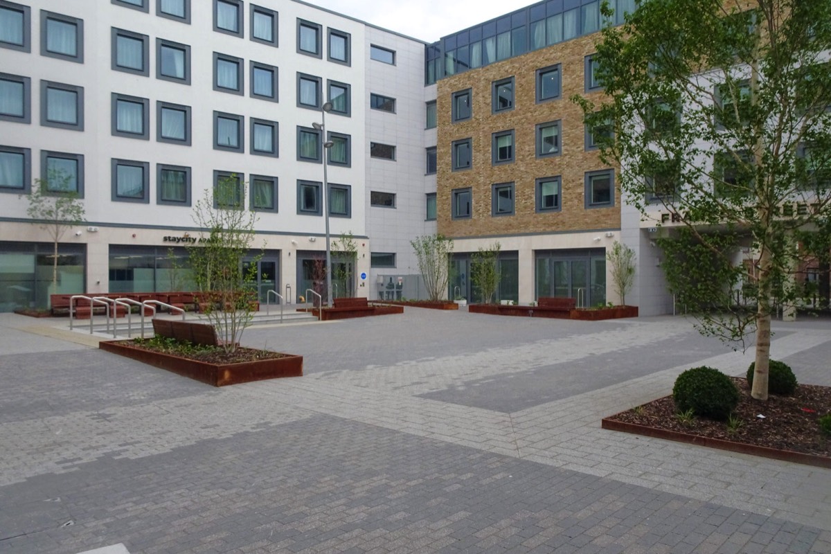
StayCity, Little Mary Street
340 bed Aparthotel progressing on site currently in the historic Markets Area of Dublin City Centre for Staycity. Ground floor reception and cafe, retail unit and artist studios make for a lively streetscape close to the main Mary Street and Henry Street thoroughfare.
Creekvale Hotel [Arran Street Hotel]
In June 2020 Dublin City Council gave the green light for an eight-storey, 273-bedroom hotel on the site of the existing Begley’s Fruit Market in Dublin’s markets area. According to the developer: "This hotel is located on Arran Street a short walk to Jervis Street Shopping Centre and Henry Street retail areas.
The project involves the construction of a new hotel and basement below ground level. A challenging project on a relatively restricted site and bustling retail environment, with the added complexities of archaeology and engineering challenges. The construction of this seven-storey building and complex façade treatment and landscape on the building will result in a top-class brand hotel."

GREEN STREETAND NEARBY
Green Street Courthouse is a courthouse between Green Street and Halston Street in the Smithfield area of Dublin, Ireland. It was the site of many widely discussed criminal trials from 1797 until 2010, when the Criminal Courts of Justice building opened.
The building held different courts, including the Dublin Commission Court (for the city and county, similar to the assizes held in other Irish counties), the city quarter sessions, and the courts of the Lord Mayor, the Sheriff, and the Recorder.
The courthouse was part of a complex which also included three prisons — Newgate (completed 1781), the Sheriff's Prison (completed 1794), and the City Marshalsea (completed 1804) — and the Governor of Newgate's residence. The Newgate prison replaced the original county gaol of the county of the city of Dublin, which was located at the New Gate of the city wall. Which prison a convict or remanded defendant stayed in depended on the court and crime; besides those on Green Street there was Richmond Bridewell south of the Liffey, and Kilmainham Gaol west of the city took prisoners from the County Commission Court. (Kilmainham Courthouse held the county quarter sessions). Because the courthouse held Commission Courts for both County Dublin and the county of the city, it was legally treated as part of both counties.
Green Street Courthouse was the venue of trials of noted Irish republican rebels, including Robert Emmet in 1803, John Mitchel in 1848, and Fenian leaders later. As well as holding trials, the Sessions House was the venue for election of members of the UK parliament for the Dublin City constituency.

CHANCERY PARK AND HOUSEDECEMBER 2021
Chancery Park is now a public park as well as an extension of Chancery House, a block of council flats designed and built as a unified complex.
This corporation housing scheme was designed by Herbert Simms, who was appointed Corporation housing architect in 1933, as part of the Housing Act of 1932, which aimed to increase the level of public housing from 2,000 to 12,000 annually.
The contractor here was G.&T. Crampton.
Simms was responsible for the design and erection of 17,000 new homes, which made a huge contribution towards solving Dublin's acute housing problem. He drew heavily from works by de Klerk in Amsterdam and J.P. Oud in Rotterdam, which can be seen in his rounded corners, projecting balconies and arched gateways, and from the De Stijl movement, as is evidenced from concrete cantilevered roofs and canopies.
Its flat roofs, overhanging eaves, galleried façade and channelled render to the upper floor contribute to the strong horizontal emphasis of the building, which is offset by external three-storey red brick blocks, the combination of brick and render surfaces distinguishing this from its contemporaries. Simms made interesting use of simple materials and forms to provide an element of visual and textural contrast. Chancery House provides an element of variety to the architectural tone of the area.

BOLTON STREETNEW PHONE KIOSK
This has been here for many months and I have yet to see anyone using the phone but at least it has yet to be vandalised.
Many are complaining online about these structures popping up all over the city when in fact they have just replaced derelict and vandalised phone kiosks that were in the same locations for decades. However, I do agree that as a pedestrian I have to deal with an excessive amount of street furniture while walking around the city.

FEGANS ON CHANCERY STREETHAWKEYE THE MURAL
Hawkeye premiered its first two episodes on November 24, 2021, and will consist of six episodes, concluding on December 22. It is part of Phase Four of the MCU. The series has received positive reviews, with critics highlighting its action sequences and the lead actors' chemistry. A spin-off series, Echo, focusing on Cox's character Maya Lopez / Echo, is in development.

LOWER DOMINICK STREETPHOTOGRAPHED 2019
I will publish photographs of the street when the current phase of the street regeneration project is complete.
A €40m project is advancing well, despite the interruptions caused by the Covid Public Health measures over the last twelve months. It is expected that construction will be completed by years’ end with the Housing Department of Dublin City Council beginning the allocation of homes in January 2022.
In total, this phase of the Dominick Street Regeneration project will see 12 one-bedroom apartments, 50 two-bedroom apartments and 10 three-bedroom apartments. Those residents who lived in the original Dominick Street complex and have Letters of Comfort or have expressed an interest in returning to the new apartment complex, will have the opportunity to accept a formal offer of alternative accommodation.
When I first use my iPhone XR a few years ago I did not realise that the images were HEIC which was a format that I could not easily process and today I was reviewing my catalogues I re-discovered many photographs from June 2019 that had been automatically converted to a usable format on the 16th November 2021. Now I know why my system had slowed to a crawl a few weeks ago.

RAILWAY BRIDGE ACROSS PEARSE STREETLOOPLINE BRIDGE
Designed by John Chaloner Smith (engineer to the Dublin, Wicklow and Wexford Railway), the bridge was built between 1889 and 1891. It consists of wrought iron lattice girders on a double row of piers with five spans. The viaduct is approximately six metres above street level and supports two railway tracks.
During original planning and construction (in the late 19th century) the project was subject to much opposition and controversy, because the structure blocks the view down river to The Custom House. However, the bridge was deemed necessary as a rail link between north and south Dublin, and to facilitate the movement of transatlantic mail coming from Kingstown (Dún Laoghaire) and Queenstown (Cobh).
100 years later, the visage of the bridge remains the subject of some debate. Already arguably less attractive than some of Dublin's other bridges, the façades of the Loopline have been used by Iarnród Éireann for billboard advertising. As of 2006, the company has scaled back the bridge's use for this purpose to reduce impact on the city skyline, following input from An Bord Pleanála and Dublin City Council.
A prominent feature in the city landscape since 1891, the Loopline Bridge appears in one of the most famous literary works associated with Dublin:
A skiff, a crumpled throwaway, Elijah is coming, rode lightly down the Liffey, under Loopline bridge, shooting the rapids where water chafed around the bridgepiers, sailing eastward past hulls and anchorchains, between the Customhouse old dock and George’s quay.
— James Joyce, Ulysses

THE LOOPLINE BRIDGERAILWAY BRIDGE ACROSS THE RIVER LIFFEY
Designed by John Chaloner Smith (engineer to the Dublin, Wicklow and Wexford Railway), the bridge was built between 1889 and 1891. It consists of wrought iron lattice girders on a double row of piers with five spans. The viaduct is approximately six metres above street level and supports two railway tracks.

PASS FREELY BY STREET ARTIST ASBESTOSCOVID MEMORIAL

POOLBEG STREETHOME TO MULLIGAN'S PUB
Most people in Dublin know of Poolbeg Street know it because it is home to Mulligan's Pub.
The first Mulligan's was established on Thomas Street, Dublin in 1782. The Mulligan family moved their business to several different premises, before leasing the present building on Poolbeg Street in 1854. Mick Smyth bought the pub from John Mulligan in 1932. Ownership later passed to Smyth's nephews, Con and Tommy Cusack, before passing to Tommy Cusack's sons.
The former Theatre Royal in Hawkins Street was near Mulligan's, and the pub walls are decorated with associated posters, photographs, and showbills dating back to the early nineteenth century, as well as an autographed photograph of Judy Garland, who performed in the theatre and drank at the pub.
The pub is mentioned briefly in James Joyce's short story, Counterparts, and was used as a filming location on a number of occasions.Journalists and writers drank at Mulligans during the twentieth century, including staff from the Irish Times and from the former Irish Press newspaper - which operated next door until the collapse of the paper in 1995. A number of Dublin musicians also drank there, as several music industry management offices were in the nearby Corn Exchange Building.

GURSHA ETHIOPIAN RESTAURANT ON POOLBEG STREET
I have never visited an Ethiopian Restaurant and I was a bit surprised to discover one on Poolbeg Street in Dublin. Unfortunately, for me, they only open from 6pm Thursday to Sunday and that does not suit my schedule. However, a friend told me that they have plans to open for lunch.

A HEART IN BLOOM BY RENATA METENE
Located Grand Canal Street Lower in Dublin. Actually I would describe it as being at Hogan Place between Upper Erne Street and Harmony Row as I once lived in the area.

BIRDSBY JULIETTE O'BRIEN
This Paint-A-Box Street Art is located on Adelaide Road in Dublin 2 and is not far from Leeson Street Bridge.
Painted back in 2018 it was designed to be a representation of stained glass windows in order to bring some nature and colour into the grey streets of the city.

A WALK ALONG ADELAIDE ROADWAS THE OLD CIRCULAR ROAD
I only recently discovered that Adelaide Road is named after Queen Adelaide who I had never heard of, I must have failed to pay attention during history classes at a nearby secondary school. In the early 1800s the road was known as the Old Circular Road.
The following buildings of interest are located on the street:
Presbyterian Church 1841 St Finian's Lutheran Church 1863 Synagogue (former) 1892 Royal Victoria Eye And Ear Hospital 1901 1929 Kiosk which was a tea room and public toilet. To the best of my knowledge the public toilet was women only. I would describe this as being on Leeson Street.
Note: Adelaide of Saxe-Meiningen (Adelaide Amelia Louise Theresa Caroline; 13 August 1792 – 2 December 1849) was Queen of the United Kingdom and Hanover from 26 June 1830 to 20 June 1837 as the wife of King William IV. Adelaide was the daughter of George I, Duke of Saxe-Meiningen, and Luise Eleonore of Hohenlohe-Langenburg. Adelaide, the capital city of South Australia, is named after her.

TEMPLE BAR HAS NOT RETURNED TO NORMALNOVEMBER 2021
Temple Bar has suffered greatly because of a series of lockdowns but life is beginning to return slowly.

STILL A WORK IN PROGRESSWOLFE TONE SQUARE

Following a campaign from local residents to restore "Wolfe Tone Park as a non-commercial green space" there has been an ongoing debate as to the future use of the park. Recently Dublin City Council began to refurbish Wolfe Tone Street and the Park and while the street may be a huge improvement I am not certain that the park will meet with expectations of local residents.
Wolfe Tone Park, sometimes known as Wolfe Tone Square, is a public space in Dublin. Named in honour of Theobald Wolfe Tone (1763–1798), the park is the site of a graveyard that was attached to St. Mary's Church. The graveyard was deconsecrated in 1966 and laid out as a green park. In 1998, Dublin City Council held an international competition to redesign the park, which was won by Peter Cody of Boyd Cody Architects and park reopened in 2001.
PAINT-A-BOX STREET ART PEARSE STREET

PAINT-A-BOX STREET ART - THE BOOK OF KELLS BY DAVID MacKEY
Using the Book of Kells with Ardagh Chalice and High Cross imagery of ancient Ireland, combined with the Harp Emblem of Ireland to bring together elements of Pearse Street and Trinity College.
https://www.dublincanvas.com/dublin-canvas-artist-profiles/david-mackey
PUBLIC PARKMERRION SQUARE

When I visited today it was foggy and the light was fading rapidly so some of the images are less than sharp.
Merrion Square Park sits at the centre of one of Dublin city's most beautiful Georgian squares. The park has been restored to its historical layout. It also has a playground and sculpture trail. The Houses of the Oireachtas (the Irish Government), the Natural History Museum and the National Gallery of Ireland sit along the west of the square.
SAINT STEPHEN'S GREENPUBLIC PARKS AND GARDENS

St Stephen's Green is a garden square and public park located in the city centre of Dublin, Ireland. The current landscape of the park was designed by William Sheppard. It was officially re-opened to the public on Tuesday, 27 July 1880 by Lord Ardilaun.
WINTER LIGHTSBY DUBLIN CITY COUNCIL
I used a iPhone 12 Pro Max and was very disappointed with the results. I had intended to photograph all 21 locations but have decided that I need a better camera solution.
I really like Christmas and as my birthday is on New Years Day I have always managed to take at least a two week break at Christmas but unfortunately because of Covid-19 restrictions I did not get to enjoy Christmas 2020. I am looking forward to Christmas 2021.
My father always brought us around the city at night during the first week in December to see the Christmas Lights and Decorations and back then many shops had impressive window displays. The window displays are now much less than impressive and the street decorations are not great however Dublin City Council has launched their very popular "Winter Lights" programme which will be active until New Years Day 2022.
21 locations, in the form of 2 walking trails around the city, have been transformed with colourful projections and lighting displays. Five new locations have been added this year including the historical Liberties area and Merrion Square Park.
This year photos of 76 people who work voluntarily in their local community will be rotated on the sails in Smithfield as part of the programme. Those featured include sports coaches, tidy towns volunteers, and charity workers.
The Lord Mayor of Dublin Alison Gilliland said she’s delighted to see the lights return: “I’ve been a huge fan of ‘Dublin Winter Lights’ ever since it began in 2018. The contrast between the bright lights and the dark evenings makes for a stunning backdrop to the city. I am delighted to see representative photos of so many of our community volunteers on the light sails of Smithfield Square. They really are the heart of every community. Our Childrens Wall on Barnardo Square will project entries from our recent Children’s Art Competition. We all need a bit of colour in our lives so I would encourage Dubliners to visit the city-centre and take in as many locations as they can. I know that’s definitely something I’ll be doing this festive season!”
No diesel generators will be used this year. Instead where main power is not available the City Council will use Hydrotreated Vegetable Oil (HVO) fuel. HVO is made from 100% renewable waste materials and results in an up to 90% reduction in CO2 emissions, up to 86% reduction in particulate matter, and up to 30% reduction nitrogen oxide emissions. The eco-friendly lights feature 157,800 low power LEDs, 100 tonnes of equipment and 15,780 metres of cable. The majority of the installations use LED powered lighting. There are three versions of the LED, 300w, 400w and a new 500w, which is replacing what last year was 2500w.
The projectors being using in Smithfield are new laser technology. The 24 projectors being are drawing a total of 13 amps which is the equivalent of a standard domestic socket. Custom House power usage last year was 40kw, whereas this year with LED, we are down to 12kw power usage. Samuel Beckett Bridge is completely LED using a total of 2kw (equivalent of vacuum cleaner).
Dublin City Council recycle all materials and branding from year to year. We store all the lighting in wooden crates each year and don’t use any single use plastics etc.

Commercial DisclosurePLEASE NOTE THAT LINKS BELOW MAY REDIRECT YOU TO THE AMAZON LOCATION MOST LIKELY TO SHIP TO YOUR ADDRESS
You will find links to buy products from Amazon, Google and other partners. If you click on these links, you’ll find that the URL includes a small extra piece of text which identifies that the click came from my websites. This text is an affiliate code, and it means that I get a small percentage of the money you spend if you choose to buy that product, or, in some cases, other products from the site soon after. These affiliate links help pay the costs of producing my websites and ensure that the content is free to you.

Zeiss Batis 85mm f/1.8 Lens for Sony E Mount, Black
I HAVE THIS AND THE 135mm LENS
VERSATILE FULL-FRAME LENS: The powerful lens for the mirrorless full-frame system of Sony fulfills the highest requirements. Despite its compact design, the image meets the expectations of professional photographers. EXCELLENT RESOLUTION AND HIGH CONTRAST: Richly saturated and vivid colours are a must in the creation of lasting impressions. However, stray light within an optical system leads to a lightening of the image that is particularly noticeable in the shadows. This reduces image contrast, with the result that exposures lack contrast and appear faded. To avoid this, ZEISS combines various specially developed technologies to reduce the undesirable effects of stray light. ROBUST AND WEATHERPROOF METAL CONSTRUCTION: Thanks to features that are designed to keep out dust and spray water, the lens is perfectly suited for critical outdoor conditions. It is also designed for many years of intensive use. SMOOTH AND RELIABLE AUTOFOCUS: The design of the autofocus system requires an extremely accurate shifting of particular lens groups. The focusing system of ZEISS lenses is designed to ensure a robust and smooth-running autofocus mechanism with the best imaging performance.
YOU SHOULD ALSO CONSIDER THE 25mm LENS