BROADSTONE


SORRY FOR THE DELAY
-
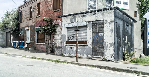
DERELICT STATION AREA
-
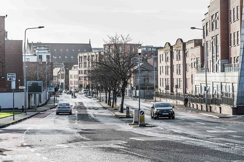
RANDOM IMAGES OF THE AREA
Broadstone is one of the three neighbourhoods that make up present-day Phibsboro. The most southerly of these, Broadstone, lies just two km due north of the Liffey Bridge at Ormond Quay Dublin, Ireland. The area is triangular, bounded by Phibsborough Road and Constitution Hill to the West, North Circular Road to the north, and Dorset Street and Bolton Street to the south-east. The postal district for the area is Dublin 7.
Broadstone was known in earlier times as Glasmanogue. The name is descriptive of a ford crossing place over the Bradogue, a Liffey tributary stream located there. The Bradogue rises in Cabra to the north-west and runs to the Liffey at Ormond Quay. It has long been culverted and now runs almost wholly underground. The Broadstone Station, a former railway terminus, is located opposite the Kings Inns at Constitution Hill.
Broadstone is home to a number of landmarks such as the Black Church (St. Mary's Chapel of Ease), King's Inns, The Broadstone Station, the Blessington Street Basin, Berkeley Road Church (St.Joseph), and Royal Canal Bank. Much of the area was originally part of the Grangegorman estate, the demesne, manor house and grounds of the Monck Minogue Stanley family.
The area consists of streets of small and mid-sized red-brick houses built after the development of the G.W.R. a century after the building of early Georgian Dublin in neighbouring Mountjoy prior to the Act of Union 1801. One notable aspect of Georgian architecture retained in these modest homes was the ornate doorways with half-circle fanlights.
Broadstone does not have a village centre or main street. The Railway Terminus was the focal point of the neighbourhood. Broadstone's importance was derived came from its location as one of Dublin's six railway termini.
Settled by Vikings, the area was part of the Manor of Grangegorman, which was famed for its vast orchards. The green was a common, used for pasture and pleasure. Late 18th-century pictures and reports describe a boggy wetland which became a quagmire in wet weather. The original Irish name of Glas Mochanog, anglicised to 'Glasmanogue', translates as Monck (variant Minogue) Green. From the Restoration in 1660 the area was used for military parades and pageants to celebrate the Restoration of Charles II, but it was not until the late 18th century and the construction of the Royal Canal that the Broadstone, Mountjoy, and Phibsboro became part of the city proper. Around this time the northern part of the city became fashionable with the Anglo-Irish political and commercial establishment, who made up the ruling and commercial Ascendancy of the emergent semi-autonomous Kingdom of Ireland. Notable among these was the Gardiner family, Earls of Blessington and Viscounts Mountjoy, after which the second Phibsboro neighbourhood of Mountjoy developed. Gardiner Street, Gardiner Place, Gardiner Lane, Gardiner Row, Blessington Street, Blessington Court, Blessington Lane, Blessington Basin, Mountjoy Street, Mountjoy Square, Mountjoy Place and Mountjoy Parade – all in the vicinity – are named for the Mountjoy developer family connections.
You will find links to buy products from Amazon, Google and other partners. If you click on these links, you’ll find that the URL includes a small extra piece of text which identifies that the click came from my websites. This text is an affiliate code, and it means that I get a small percentage of the money you spend if you choose to buy that product, or, in some cases, other products from the site soon after. These affiliate links help pay the costs of producing my websites and ensure that the content is free to you.
COPYRIGHT INFORMATION BELOW APPLIES ONLY TO PHOTOGRAPHS

This work by William Murphy aka Infomatique is licensed under a Creative Commons Attribution-NonCommercial-ShareAlike 4.0 International License.
Permissions beyond the scope of this license may be available at https://excellentstreetimages.com/in-the-year-twentytwenty/copyright/.