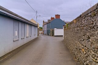
PHOTOGRAPHED IN AUGUST 2018
IN KILKENNY THERE IS A NETWORK ON LANES SURROUNDING THE CATHEDRAL [LEGACY IMAGES FROM 2018]
If you take a guided tour of Kilkenny this is the network of lanes that you are likely to explore.
The Cathedral Enclosure and its Arteries
The area surrounding St Canice's Cathedral, known as the Cathedral Close, was historically defined by concentric circular enclosures typical of early medieval monastic foundations (Kilkenny County Council, n.d.). These enclosures dictated the curving street patterns seen today in Vicar Street, St Canice's Place, and Coach Road (Kilkenny County Council, n.d.).
Vicar Street: Once home to the Vicars Choral, this street served as a residence for church dignitaries. While many original structures have been modernised, the street still contains remains of 16th-century walls and Tudor-style windows (Phelan & Gibb, 1956).
St Canice's Place (Ancient Bull Alley): Originally a narrow path where residents could nearly "shake hands across the roadway," it was widened in the 19th century. It took its name from the Bull Inn, a Tudor-period stone structure whose ruins were a local landmark for centuries (Phelan & Gibb, 1956).
Coach Road and Church Lane: These paths provided direct access to the cathedral and the Bishop's Palace. Church Lane is notable for the Sexton’s House (originally the Precentor’s Manse, c. 1640), which features an original round-headed entrance door and nearby 6th-century effigies (Kilkenny County Council, n.d.).
Architectural and Strategic Significance
The laneways near the cathedral were designed for both utility and defence. Their narrow, winding configurations made them easily defensible against invaders, while also serving as vital conduits for the transport of goods to the "Irishtown" district (Smithwick's Experience, n.d.). Many of these lanes originated from burgage plots—long, narrow strips of land established in 1207 by William Marshal. These plots required alleyways to provide light and access to the interior of deep buildings, resulting in the dense network of "slips" that characterise the city today (Kilkenny County Council, 2026).
If you take a guided tour of Kilkenny this is the network of lanes that you are likely to explore.
The Cathedral Enclosure and its Arteries
The area surrounding St Canice's Cathedral, known as the Cathedral Close, was historically defined by concentric circular enclosures typical of early medieval monastic foundations (Kilkenny County Council, n.d.). These enclosures dictated the curving street patterns seen today in Vicar Street, St Canice's Place, and Coach Road (Kilkenny County Council, n.d.).
Vicar Street: Once home to the Vicars Choral, this street served as a residence for church dignitaries. While many original structures have been modernised, the street still contains remains of 16th-century walls and Tudor-style windows (Phelan & Gibb, 1956).
St Canice's Place (Ancient Bull Alley): Originally a narrow path where residents could nearly "shake hands across the roadway," it was widened in the 19th century. It took its name from the Bull Inn, a Tudor-period stone structure whose ruins were a local landmark for centuries (Phelan & Gibb, 1956).
Coach Road and Church Lane: These paths provided direct access to the cathedral and the Bishop's Palace. Church Lane is notable for the Sexton’s House (originally the Precentor’s Manse, c. 1640), which features an original round-headed entrance door and nearby 6th-century effigies (Kilkenny County Council, n.d.).
Architectural and Strategic Significance
The laneways near the cathedral were designed for both utility and defence. Their narrow, winding configurations made them easily defensible against invaders, while also serving as vital conduits for the transport of goods to the "Irishtown" district (Smithwick's Experience, n.d.). Many of these lanes originated from burgage plots—long, narrow strips of land established in 1207 by William Marshal. These plots required alleyways to provide light and access to the interior of deep buildings, resulting in the dense network of "slips" that characterise the city today (Kilkenny County Council, 2026).


THE LANES OF KILKENNY