DUBLIN 6 NOVEMBER 2025
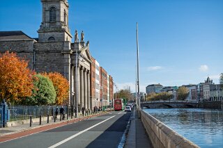
DUBLIN QUAYS AND NEARBY 6 NOVEMBER 2025 [I USED A SONY SEL 30mm MACRO LENS AND AN FX30 BODY]
Today as I was on my way to meet some friends at Eatokyo Restaurant in Wellington I took the opportunity to photograph sections of the Quays, North and South.
It is a vastly more pleasant experience to walk along the quays upriver from O'Connell Bridge now, precisely because of the recent traffic restrictions.
This improvement is a direct result of the Dublin City Centre Transport Plan, which began its phased rollout in 2024. The changes you're noticing are not just a side effect; they are the specific goal of the plan.
Here is a discussion of how these restrictions have transformed the pedestrian experience in that specific area.
1. The Core Problem: A "Watery Dual Carriageway"
For decades, the quays—particularly Bachelors Walk and Aston Quay (bordering Temple Bar)—functioned as a high-volume, east-west artery for private cars. Dublin City Council officials noted that over 60% of this traffic was "through traffic," meaning drivers who were not stopping in the city centre but just using the quays as a shortcut.
This volume of cars created a hostile environment for pedestrians:
Noise Pollution: The constant roar of traffic drowned out the sound of the river and the city.
Air Pollution: Walkers were exposed to a constant stream of exhaust fumes.
Safety Concerns: The narrow footpaths, especially along the Liffey Boardwalk on Bachelors Walk, felt unsafe as they were separated from multiple lanes of fast-moving traffic by only a narrow kerb.
2. The New Restrictions (The "Bus Gates")
The most significant change, which came into effect in August 2024, was the introduction of "bus gates" on the quays immediately west of O'Connell Bridge.
On the Northside (Bachelors Walk): General traffic is no longer permitted to drive straight through towards Eden Quay (east of O'Connell Bridge). Private cars are now directed to turn left onto O'Connell Street, effectively stopping them from using the quays as a through-route.
On the Southside (Aston Quay): Similarly, general traffic travelling east on Wellington Quay is no longer allowed to continue straight onto Aston Quay. This space is now reserved for buses, taxis, cyclists, and pedestrians.
3. The Impact: Reclaiming the Riverfront
These changes have had an immediate and profound effect on the walking experience, transforming the quays from a "traffic sewer" into a genuine civic amenity.
A Drastic Reduction in Noise and Fumes: With the removal of thousands of private cars daily, the ambiance is significantly calmer. You can now stand on the Liffey Boardwalk, look across to Temple Bar, and have a conversation without shouting.
A Greater Sense of Space and Safety: The primary benefit for pedestrians is the creation of a "buffer." The space previously occupied by cars has been reallocated to new bus lanes and, crucially, a segregated two-way Liffey Cycle Route. This cycle path now sits between the pedestrians on the boardwalk and the remaining bus traffic, creating a much safer and more relaxed environment.
A Shift in Focus: The quays are becoming less of a transit corridor and more of a destination. The new restrictions encourage people to slow down and appreciate the riverside. This change makes walking further upriver—past the Ha'penny Bridge towards Ormond Quay and Inns Quay (home of the Four Courts)—a much more appealing prospect, as the entire corridor feels calmer.
In short, the new traffic plan has successfully prioritised people over cars in the city's core. By restricting through-traffic, the council has given the quays back to pedestrians and cyclists, making a walk along the Liffey a pleasant experience rather than an endurance test.
The quays of Dublin are the stone-faced embankments that form the banks of the River Liffey, functioning as both major thoroughfares and foundational elements of the city's history. Upriver (west) from O'Connell Street Bridge, these quays trace the path of the original, older city, including the site of its Viking and Medieval origins.
The Quays Upriver from O'Connell Bridge
Travelling westwards from O'Connell Bridge, the quays are named in a series of distinct sections on both the north and south banks:
North Bank (Northside):
Bachelors Walk
Ormond Quay Lower
Ormond Quay Upper
Inns Quay
Arran Quay
Ellis Quay
Sarsfield Quay
Wolfe Tone Quay
South Bank (Southside):
Aston Quay
Crampton Quay
Wellington Quay
Essex Quay
Wood Quay
Merchant's Quay
Usher's Quay
Usher's Island
Victoria Quay
Relationship to the River Liffey
The relationship between these quays and the River Liffey is fundamental; the quays exist because of the river, and the modern city exists largely because of the quays.
Original Purpose (Taming and Trade): The Liffey was not always the tidy, channelled river seen today. It was originally a wide, tidal estuary with marshy banks and mudflats. The quays were built over centuries to tame the river, reclaim land, prevent flooding, and, most importantly, provide deep-water access for ships. The area around Wood Quay is famously the heart of the original Viking settlement, Dyflin, chosen specifically for its position on the river.
Commercial Artery: For centuries, the Liffey was Dublin's main highway. The quays functioned as the city's working port, with ships loading and unloading goods directly onto them. Merchant's Quay and Wood Quay were the epicentres of this Medieval maritime trade. This commercial function defined the area, with warehouses, customs posts, and guildhalls lining the riverfront.
Civic and Urban Development: The construction of the quays allowed for the city's structured westward expansion. In the 17th century, the Duke of Ormond decreed that the houses built along his new quays (such as Ormond Quay) must face the river, turning the Liffey into a grand urban centrepiece rather than a functional backyard. This vision was later cemented by the construction of major civic buildings, most notably The Four Courts on Inns Quay, which deliberately uses the river as its majestic foreground.
Modern Role: While large-scale shipping has long since moved downriver to Dublin Port, the quays remain vital. They function as a primary transport corridor, with the north and south quays forming a one-way system that bisects the city. In recent times, their relationship with the Liffey has evolved from purely industrial to include leisure. The construction of the Liffey Boardwalk (along Bachelors Walk, Ormond Quay, and Arran Quay) has re-established the quays as a place for pedestrians, re-connecting Dubliners and visitors with the river itself.
In essence, the quays upriver from O'Connell Bridge tell the story of Dublin's birth and growth. They are the man-made structures that harnessed the Liffey, transforming it from a natural barrier into the central spine of the city.