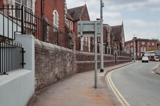
I USED A LEICA Q3 FOR THIS SESSION IN APRIL 2026
THE HISTORIC SOUTH SIDE OF CORK [A LEICA Q3 SESSION 21 APRIL 2026]
The Architectural Layers of Cork’s Historic South Side: A Documented Walking Survey
Because of my editing and naming process the photographs are at random but all are GEO-Tagged so if you are interested they can be exactly located if necessary.
The urban landscape stretching south of the River Lee’s south channel comprises one of the oldest, topographically complex, and architecturally varied quarters in Cork City. A recent photographic and topographical survey traced a comprehensive loop through this district, mapping the transition from low-lying industrial river margins up to the steep military and ecclesiastical heights, before descending back through medieval trading corridors to the waterfront.
This survey documents the vernacular architecture, industrial footprints, and hidden urban enclaves that define the historic South Parish and its immediate surroundings.
Phase 1: The Industrial Waterfront and River Margins
The survey commenced at the intersection of Wandesford Street and Sharman Crawford Street, an area historically dictated by the marshy channels of the river and heavy industry. Sharman Crawford Street is dominated by the monumental limestone and brick architecture of the former Beamish & Crawford brewery, established in 1792. The built environment here is characterized by large-scale commercial facades and robust masonry, anchoring the lower edge of the district near Clarke’s Bridge (1776). The transition from the open, water-adjacent industrial spaces to the tighter urban core begins immediately upon moving away from the quayside.
Phase 2: The Ecclesiastical and Military Heights
Ascending via Bishop Street and Dean Street, the topography rises sharply into the ancient heart of the early settlement. The presence of St Fin Barre’s Cathedral establishes an ecclesiastical scale that contrasts abruptly with the narrow, defensive lanes immediately to the east.
Turning onto Fort Street and Vicar Street, the architecture shifts toward a military character, dictated by the massive stone bastion walls of Elizabeth Fort, a seventeenth-century star fort. Barrack Street serves as the primary ancient highway leading into the city from the south. The streetscape along this spine is a mixture of traditional multi-storey shopfronts and narrow residential infills, constructed to service the garrison and the bustling trade route.
Phase 3: The Artisan Lanes and the Landlocked Folly of the South Parish
The core of the photographic documentation focused on Tower Street and the dense web of nineteenth-century artisan lanes branching from it, including Long's Yard, St Finbarrs Street, St Brigid Street, and St Nessan Street. This specific zone represents the rapid Victorian expansion of the South Parish, built to house workers from the nearby breweries, brickworks, and quays.
The architecture is predominantly vernacular, consisting of modest, single-fronted and double-fronted worker cottages that conform to the steep gradients of the terrain. Enclaves such as Long’s Yard preserve a highly localized, intimate scale of urban living that is increasingly rare in modern city centres.
This cluster of streets orbits a significant, though hidden, architectural focal point: Callanan’s Tower. Visible primarily as a crenellated silhouette on the skyline from distant vantage points, this four-stage stone folly was erected around 1861 by Michael Callanan as the centrepiece of the short-lived Tower Gardens pleasure grounds, which opened in 1865. Following the rapid financial failure and closure of the gardens by 1868, the surrounding land was progressively built over. Today, the nineteenth-century residential streetscape completely encloses the tower, rendering it landlocked on private property and inaccessible from the public street, a silent monument around which the modern parish evolved.
The survey extended further south along the steep incline of Friar's Walk and its minor offshoots, before cresting at Mount Sion Road. This vantage point illustrates the dramatic verticality of Cork's southern ridge, where rows of terraced cottages step down the hillside, offering sweeping, layered vistas across the roofs of the inner city.
Phase 4: The Monastic Suburb and the Return to the Quay
Doubling back toward the urban centre, the route followed the historic trading spine of Evergreen Street and Douglas Street. These streets retain the irregular, organic alignment of a medieval suburb, characterized by varying building heights, traditional timber shopfronts, and rendering over solid stone walls.
Abbey Street provides the primary physical link to the oldest surviving structure in the area, the thirteenth-century tower of the Red Abbey, a remnant of the Augustinian monastery. The survey concluded by traversing Mary Street and Cove Street, where the residential scale gradually transitions back into commercial premises, before terminating at Sullivan’s Quay on the waterfront, completing a full geographical and historical loop.
The Architectural Layers of Cork’s Historic South Side: A Documented Walking Survey
Because of my editing and naming process the photographs are at random but all are GEO-Tagged so if you are interested they can be exactly located if necessary.
The urban landscape stretching south of the River Lee’s south channel comprises one of the oldest, topographically complex, and architecturally varied quarters in Cork City. A recent photographic and topographical survey traced a comprehensive loop through this district, mapping the transition from low-lying industrial river margins up to the steep military and ecclesiastical heights, before descending back through medieval trading corridors to the waterfront.
This survey documents the vernacular architecture, industrial footprints, and hidden urban enclaves that define the historic South Parish and its immediate surroundings.
Phase 1: The Industrial Waterfront and River Margins
The survey commenced at the intersection of Wandesford Street and Sharman Crawford Street, an area historically dictated by the marshy channels of the river and heavy industry. Sharman Crawford Street is dominated by the monumental limestone and brick architecture of the former Beamish & Crawford brewery, established in 1792. The built environment here is characterized by large-scale commercial facades and robust masonry, anchoring the lower edge of the district near Clarke’s Bridge (1776). The transition from the open, water-adjacent industrial spaces to the tighter urban core begins immediately upon moving away from the quayside.
Phase 2: The Ecclesiastical and Military Heights
Ascending via Bishop Street and Dean Street, the topography rises sharply into the ancient heart of the early settlement. The presence of St Fin Barre’s Cathedral establishes an ecclesiastical scale that contrasts abruptly with the narrow, defensive lanes immediately to the east.
Turning onto Fort Street and Vicar Street, the architecture shifts toward a military character, dictated by the massive stone bastion walls of Elizabeth Fort, a seventeenth-century star fort. Barrack Street serves as the primary ancient highway leading into the city from the south. The streetscape along this spine is a mixture of traditional multi-storey shopfronts and narrow residential infills, constructed to service the garrison and the bustling trade route.
Phase 3: The Artisan Lanes and the Landlocked Folly of the South Parish
The core of the photographic documentation focused on Tower Street and the dense web of nineteenth-century artisan lanes branching from it, including Long's Yard, St Finbarrs Street, St Brigid Street, and St Nessan Street. This specific zone represents the rapid Victorian expansion of the South Parish, built to house workers from the nearby breweries, brickworks, and quays.
The architecture is predominantly vernacular, consisting of modest, single-fronted and double-fronted worker cottages that conform to the steep gradients of the terrain. Enclaves such as Long’s Yard preserve a highly localized, intimate scale of urban living that is increasingly rare in modern city centres.
This cluster of streets orbits a significant, though hidden, architectural focal point: Callanan’s Tower. Visible primarily as a crenellated silhouette on the skyline from distant vantage points, this four-stage stone folly was erected around 1861 by Michael Callanan as the centrepiece of the short-lived Tower Gardens pleasure grounds, which opened in 1865. Following the rapid financial failure and closure of the gardens by 1868, the surrounding land was progressively built over. Today, the nineteenth-century residential streetscape completely encloses the tower, rendering it landlocked on private property and inaccessible from the public street, a silent monument around which the modern parish evolved.
The survey extended further south along the steep incline of Friar's Walk and its minor offshoots, before cresting at Mount Sion Road. This vantage point illustrates the dramatic verticality of Cork's southern ridge, where rows of terraced cottages step down the hillside, offering sweeping, layered vistas across the roofs of the inner city.
Phase 4: The Monastic Suburb and the Return to the Quay
Doubling back toward the urban centre, the route followed the historic trading spine of Evergreen Street and Douglas Street. These streets retain the irregular, organic alignment of a medieval suburb, characterized by varying building heights, traditional timber shopfronts, and rendering over solid stone walls.
Abbey Street provides the primary physical link to the oldest surviving structure in the area, the thirteenth-century tower of the Red Abbey, a remnant of the Augustinian monastery. The survey concluded by traversing Mary Street and Cove Street, where the residential scale gradually transitions back into commercial premises, before terminating at Sullivan’s Quay on the waterfront, completing a full geographical and historical loop.
CORK SOUTHSIDE