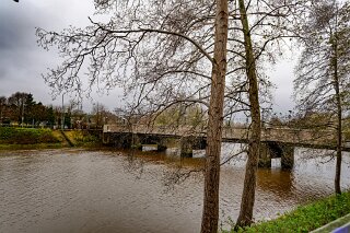
THE LAGAN LOOP NEAR STRANMILLIS
A TALE OF TWO BRIDGES - PHOTOGRAPHING THE LAGAN LOOP [THE URBAN CARTOGRAPHER 2025]
A Tale of Two Bridges: Photographing the Lagan Loop
If you walk the stretch of the River Lagan between Stranmillis and Annadale, you aren’t just observing a river; you are walking through a timeline of Belfast’s engineering history. I recently photographed the embankments between King’s Bridge and Governor’s Bridge, a compact loop that offers a fascinating study in contrasts.
On one side, you have the Edwardian grandeur of the early 20th century; on the other, the stark functionality of the 1970s. Here is a look at the history hidden in the concrete and water of this unique area.
The Historic Anchor: King’s Bridge
The most visually striking structure in this stretch is undoubtedly King’s Bridge. If you look closely at the arches and the texture of the parapets in your photos, you might assume it is built of stone, but it is actually a landmark of industrial innovation.
Opened in 1912, King’s Bridge is widely believed to be the first reinforced concrete road bridge in Ireland. It was constructed using the "Kahn System," a specific method of shaping steel bars within concrete that was cutting-edge technology at the time. The engineers of 1912 were eager to use new materials but still wanted the structure to possess a classical aesthetic, hence the decorative arches.
Named after King George V, who had been crowned just two years prior, the bridge originally connected Sunnyside Street to Ridgeway Street before the long, formal embankments were even fully developed. Today, it carries traffic out of the city towards Annadale, standing as a durable testament to Belfast’s pre-war ambition.
The Modern Relief: Governor’s Bridge
Parallel to the historic King’s Bridge lies its younger, purely functional sibling: Governor’s Bridge. The contrast in your photographs will likely be sharp. While King’s Bridge attempts to beautify its structure, Governor’s Bridge is a utilitarian beam bridge, prioritising efficiency over form.
By the early 1970s, the narrow 1912 bridge could no longer cope with the volume of two-way modern traffic. Governor’s Bridge was opened in 1974 to relieve this pressure, effectively turning the two bridges into a one-way gyratory system. It carries traffic into the city (Westbound).
It is named after Lord Grey of Naunton (Ralph Grey), the last Governor of Northern Ireland before the post was abolished in 1973. It serves as a stark reminder of the shift in civil engineering philosophy—where the decorative flourishes of the Edwardian era gave way to the concrete pragmatism of the late 20th century.
The Embankments: Stranmillis vs. Annadale
Walking the loop between these bridges also highlights the different distinct personalities of the riverbanks, often referred to by local rowers as the "Stranmillis Narrows."
The Stranmillis Embankment (West Bank) This is the social heartbeat of the river. If your photos captured the western bank, you likely included the bustling Cutters Wharf or the historic boathouses of Queen’s University and the Belfast Rowing Club. This side of the river has a vibrant, active atmosphere, serving as the gateway to the Stranmillis Village.
The Annadale Embankment (East Bank) In contrast, the eastern bank feels quieter and greener. It borders a sweeping curve of housing that leads up toward Belvoir Forest Park. The name "Annadale" is a nod to the 18th century; it was named after Anne Hill, the mother of the Duke of Wellington, who lived in the area when it was still a rural estate.
The Lagan Gateway
Just upstream from Governor’s Bridge, the river landscape is changing once again. If you looked past the bridges, you may have spotted the weir and the recent developments of the Lagan Gateway.
This area was historically the "end of the line" for tidal water and heavy shipping. Recently, a new pedestrian footbridge and a restored lock (Stranmillis Lock) have revitalised the old navigation routes that once allowed barges to travel all the way to Lough Neagh. It adds a third layer of history to the area: the 18th-century canal system, the 20th-century road bridges, and the 21st-century leisure infrastructure.
Photographing this area provides more than just scenic river views; it captures the evolution of Belfast’s infrastructure. From the pioneering concrete of 1912 to the functional relief of 1974, these two bridges and their embankments tell the story of a city constantly adapting to new demands while trying to preserve its connection to the water.
A Tale of Two Bridges: Photographing the Lagan Loop
If you walk the stretch of the River Lagan between Stranmillis and Annadale, you aren’t just observing a river; you are walking through a timeline of Belfast’s engineering history. I recently photographed the embankments between King’s Bridge and Governor’s Bridge, a compact loop that offers a fascinating study in contrasts.
On one side, you have the Edwardian grandeur of the early 20th century; on the other, the stark functionality of the 1970s. Here is a look at the history hidden in the concrete and water of this unique area.
The Historic Anchor: King’s Bridge
The most visually striking structure in this stretch is undoubtedly King’s Bridge. If you look closely at the arches and the texture of the parapets in your photos, you might assume it is built of stone, but it is actually a landmark of industrial innovation.
Opened in 1912, King’s Bridge is widely believed to be the first reinforced concrete road bridge in Ireland. It was constructed using the "Kahn System," a specific method of shaping steel bars within concrete that was cutting-edge technology at the time. The engineers of 1912 were eager to use new materials but still wanted the structure to possess a classical aesthetic, hence the decorative arches.
Named after King George V, who had been crowned just two years prior, the bridge originally connected Sunnyside Street to Ridgeway Street before the long, formal embankments were even fully developed. Today, it carries traffic out of the city towards Annadale, standing as a durable testament to Belfast’s pre-war ambition.
The Modern Relief: Governor’s Bridge
Parallel to the historic King’s Bridge lies its younger, purely functional sibling: Governor’s Bridge. The contrast in your photographs will likely be sharp. While King’s Bridge attempts to beautify its structure, Governor’s Bridge is a utilitarian beam bridge, prioritising efficiency over form.
By the early 1970s, the narrow 1912 bridge could no longer cope with the volume of two-way modern traffic. Governor’s Bridge was opened in 1974 to relieve this pressure, effectively turning the two bridges into a one-way gyratory system. It carries traffic into the city (Westbound).
It is named after Lord Grey of Naunton (Ralph Grey), the last Governor of Northern Ireland before the post was abolished in 1973. It serves as a stark reminder of the shift in civil engineering philosophy—where the decorative flourishes of the Edwardian era gave way to the concrete pragmatism of the late 20th century.
The Embankments: Stranmillis vs. Annadale
Walking the loop between these bridges also highlights the different distinct personalities of the riverbanks, often referred to by local rowers as the "Stranmillis Narrows."
The Stranmillis Embankment (West Bank) This is the social heartbeat of the river. If your photos captured the western bank, you likely included the bustling Cutters Wharf or the historic boathouses of Queen’s University and the Belfast Rowing Club. This side of the river has a vibrant, active atmosphere, serving as the gateway to the Stranmillis Village.
The Annadale Embankment (East Bank) In contrast, the eastern bank feels quieter and greener. It borders a sweeping curve of housing that leads up toward Belvoir Forest Park. The name "Annadale" is a nod to the 18th century; it was named after Anne Hill, the mother of the Duke of Wellington, who lived in the area when it was still a rural estate.
The Lagan Gateway
Just upstream from Governor’s Bridge, the river landscape is changing once again. If you looked past the bridges, you may have spotted the weir and the recent developments of the Lagan Gateway.
This area was historically the "end of the line" for tidal water and heavy shipping. Recently, a new pedestrian footbridge and a restored lock (Stranmillis Lock) have revitalised the old navigation routes that once allowed barges to travel all the way to Lough Neagh. It adds a third layer of history to the area: the 18th-century canal system, the 20th-century road bridges, and the 21st-century leisure infrastructure.
Photographing this area provides more than just scenic river views; it captures the evolution of Belfast’s infrastructure. From the pioneering concrete of 1912 to the functional relief of 1974, these two bridges and their embankments tell the story of a city constantly adapting to new demands while trying to preserve its connection to the water.
THE LAGAN LOOP