The Actual Physical Walls Of Waterford And Associated Murals By John Verling - Presented By The William Murphy - The Urban Cartographer
LET MISTER SCREEN ASSIST YOU
GLOBAL INDEXTHE CURRENT PHOTO DIARY
GO THEREThe Urban Cartographer
TECHNICAL STUFFMOBILE FRIENDLY AND FASTER
GO THEREExplore the history, extant towers, and lost fortifications of Waterford's medieval city walls. Discover the 1994 civic murals by John Verling, ongoing lime-mortar conservation methods, and current property-rights management surrounding Ireland's oldest urban defences.
MORE MURALS BY SHANE SUTTON
SONY A7RII
The Actual Physical Walls Of Waterford And Associated Murals By John Verling - Presented By William Murphy - The Urban Cartographer - Sony A7RII Photographed May 2026
The Actual Physical Walls Of Waterford And Associated Murals By John Verling
Author: William Murphy - The Urban Cartographer
|
25. Aug 2026
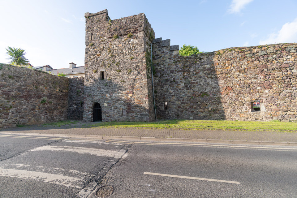
I USED A SONY A7RII AND A SONY NEX-7 So why am I now only publishing photographs from 2016 People often ask why I hold back photographs for years before publishing them. The simple answer is that this is a long-term documentary project rather than immediate reportage. My aim is to pair visual records of our historic and built environments with detailed historical context, tracking the condition, repurposing, and fate of individual structures. Allowing a decade to elapse between initial capture in 2016 and publication today provides the perspective required to measure genuine urban evolution rather than transient cosmetic shifts. The medieval town walls of Waterford represent the most extensive surviving network of medieval urban defences in Ireland. Originally encompassing a circuit of roughly 2,450 metres enclosing the Viking core and its later Anglo-Norman expansions, approximately 1.5 to 2 kilometres of wall masonry and six defensive towers survive in various states of preservation. Six of the original seventeen mural towers survive along the city’s circuit: Reginald's Tower: The apex of the Viking Triangle and the most famous secular monument in the city. Built by the Anglo-Normans in the 12th to early 13th century atop earlier Viking foundations, this massive circular stone fortress served as a fortress, royal mint, prison, and artillery store. The Double Tower (Castle Street): A rectangular 15th-to-16th-century tower containing two distinct interior chambers. One chamber originally carried a flight of stone stairs to the wall-walk, while the other formed a protected passage giving Benedictine monks access to the Church of St John’s Priory. The French Tower: Positioned at the highest point of the south-western wall on Castle Street. Circular in plan, it dates from the 13th to 14th centuries and likely derives its name from the French Huguenot community who settled in this quarter during the late 17th century. The Watch Tower (Railway / St Patrick’s Tower): A cylindrical mural tower on Castle Street featuring stepped Irish battlements and musket loops. It was strategically designed as an elevated signalling post to control the wall-walk and guard the southern approaches. The Semi-Lunar Tower: A D-shaped (horseshoe) flanking tower on the western defensive line along Patrick Street. Projecting outwards from the curtain wall, its semi-circular profile eliminated blind spots and deflected oncoming siege bombardment. The Beach Tower: Situated near Jenkins’ Lane on the north-western perimeter. Built on a rocky outcrop above the River Suir, this round flanking tower preserves distinctive 15th-century stepped crenellations and was heavily adapted for gunpowder artillery in the Tudor era. The majority of Waterford's riverfront defences and landward gate-towers were demolished between 1695 and 1710 to facilitate civic expansion, port trade, and carriage transport: Turgesius’s Tower: Stood at the corner of Barronstrand Street and the Quay, marking the north-western terminal of the primary Viking defensive triangle. Demolished in the 18th century. St Martin’s Gate & Flanking Twin Towers: Located near the intersection of Spring Garden Alley and Lady Lane. It featured a heavily defended gatehouse flanked by two mural towers and a portcullis; foundation masonry was rediscovered during archaeological digs in 1983. Colbeck Gate & Tower: Controlled the eastern exit towards the marshland and the River John near Reginald’s Tower. Arundel’s Gate & Tower: Positioned at the western town wall in the modern Arundel Square area, protecting one of the busiest trading conduits into the Anglo-Norman borough. St Patrick’s Gate & Tower: Stood on the western line near George's Street / Patrick Street, controlling the overland approach from the west. Quayside Flanking Towers: A series of smaller rectangular and semi-circular towers punctuating the quay wall along the River Suir, demolished in 1705 when the quays were widened to accommodate larger shipping wharves. The 1994 historical mural scheme in Waterford was created by the noted Irish visual artist, illustrator, and draughtsman John Verling (1943–2009). Artist Background: Born in Portlaw, County Waterford, Verling originally studied architecture at the Crawford School of Art in Cork before establishing an international reputation in egg tempera painting, book illustration, and ceramic design. Context of the 1994 Panels: Commissioned as part of civic interpretation programmes in the mid-1990s, Verling applied his deep background in architectural draughtsmanship to illustrate the evolution of Waterford's medieval masonry, urban enclosures, and streetscape heritage. Style & Impact: Verling’s public panels were characterised by meticulous structural detail combined with expressive, graphic narrative scenes of medieval guild life, stonemasons at work, and defensive battles, setting an early standard for visual historic interpretation in the city. Conservation Framework & Maintenance The surviving wall network is maintained through a partnership between Waterford City & County Council, the Heritage Council, and the Irish Walled Towns Network (IWTN), with statutory oversight from the National Monuments Service (OPW). The adopted restoration approach prioritises minimal intervention and conservative repair: Mortar Compatibility: Removal of damaging 19th/20th-century Portland cement renders and re-pointing exclusively with breathable, slaked lime mortars matching the original lime-and-sand aggregate. Soft-Capping: Exposed wall heads are stabilised using sacrificial turf or lime capping to prevent water infiltration and frost wedging without introducing artificial visual barriers. Vegetation Management: Controlled, systematic removal of invasive root networks (such as ivy, valerian, and Buddleja) that dislodge structural stone. Property Rights & Boundary Issues A major challenge in managing Waterford's city walls stems from fragmented land ownership: Landlocked Sections: Significant stretches of the curtain wall form private boundary markers, party walls, and rear garden enclosures for residential and commercial premises. Access Constraints: Because sections run through private yards, routine structural inspections, condition surveying, and preventative maintenance often require negotiated access agreements with multiple individual titleholders. Legal Protections vs Private Title: The entire surviving circuit is designated as a National Monument and listed on the Record of Monuments and Places (RMP). Under the National Monuments Acts (1930–2014), private property owners cannot alter, drill, demolish, or construct against the medieval wall without formal ministerial consent, occasionally leading to development constraints in tight urban plots. 2016 Visit To The Medieval Museum
* In The Year 2008
* In The Year 2011
* In The Year 2017
* Henrietta Back In 2010 * Clontarf Railway Station
* Docklands Railway Station
* Malahide Railway Station Ballybeg Park Mount Sion Avenue Stephen Street Thomas Street O'Connell Street Parnell Street The Forum Hub Multi-Site & Citywide Installations O'Connell Cultural Quarter (O'Connell St / George's St / Gladstone St) The Glen / Ballybricken The Apple Market / Railway Square Millers Marsh / Waterside New Street / Apple Market O'Connell Street & Cultural Quarter Stephen Street / Mayor's Walk The Mall / Waterfront The Glen & Green Street Ballybricken Barrack Street / Mount Sion City Centre & Quays
Actual Physical Walls Of Waterford
City Walls
The Extant Towers
Lost (Non-Extant) Towers and Fortified Gates
The 1994 Murals by John Verling
Maintenance, Conservation Approach, and Property Rights
THE LEGACY CATALOG
Railway Stations
Examples Of Waterford Walls Murals
Waterford Walls 2025 Locations
Waterford Walls 2024 (10th Anniversary Highlights)
Waterford Walls 2023 Highlights
Waterford Walls 2022 Highlights
HIGH RESOLUTION PHOTOGRAPHS PLUS MAP
SONY A7RII
LET MISTER SCREEN DIRECT YOU
GLOBAL INDEX OF PHOTO GALLERIES
HENRY MOORE SCULPTURE AT TRINITY
THE URBAN CARTOGRAPHER
MORE MURALS BY SHANE SUTTON
The Actual Physical Walls Of Waterford And Associated Murals By John Verling - Presented By The William Murphy - The Urban Cartographer
Who Is Building An Experience Which Is Getting Better Day By Day