I HOPE TO EXPLORE IN GREATER DETAIL SOONER RATHER THAN LATER
THE DALE IS A HIDDEN RAVINE VALLEY AND STREET IN DROGHEDA [I WILL EXPLORE AT A LATER DATE]
The hidden street which I encountered today is The Dale, a secluded ravine valley and street tucked away just south of the River Boyne in Drogheda, County Louth.
Street Layout: Cul-de-Sac or Nature Link?
Vehicular Layout: For cars, The Dale operates as a quiet cul-de-sac accessed from the Marsh Road, terminating near the foot of the valley.
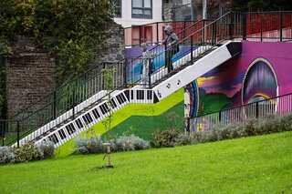
Pedestrian Connection: For walkers, it is definitely not a dead end. It acts as an urban green corridor and pedestrian trail. The steep steps featured in my photograph—brightened with painted piano keys and civic murals—connect the lower dale to the high ground near St Mary’s Cottages and the historic town wall. Known locally in conjunction with the historic 101 Steps, this pedestrian network continues towards Patrickswell Steps and nearby green heritage paths.
The Archway: The stone arch at the townward end carries the elevated Dublin Road and roadway embankment overhead, separating the secluded natural drop of the valley from the busier quayside traffic along the Boyne.
History
Natural Medieval Bulwark: The Dale is a natural glacial-melt valley that once formed part of Drogheda's south-eastern defensive geography, sitting directly below the ancient town walls and St Mary's Church.
The Cromwellian Siege (1649): The area holds dark military significance. Oliver Cromwell identified the vantage above the precipitous valley of The Dale as the weakest sector of Drogheda’s fortifications. His forces bombarded the wall adjacent to St Mary’s Church from across the valley and stormed through breaches here during the infamous Siege of Drogheda.
Industrial & Domestic Past: In the 18th and 19th centuries, a stream flowing along the base of the dale powered local industry—including James’s Street Brewery—while modest terraced cottages housed local workers and river hands.
Current Status
In recent years, The Dale has been reclaimed as an urban biodiversity pocket and cultural asset. Community clean-ups and regeneration initiatives led by local groups (such as the Red Door Project) uncovered forgotten stretches of the medieval town wall that had been swallowed by ivy. Street artists and tidy towns volunteers gave the infrastructure a lift, transforming the flight of concrete steps into public art. Today, it forms part of guided heritage walking loops connecting St Peter’s, St Laurence Gate, and Scotch Hall into the green space below.
The hidden street which I encountered today is The Dale, a secluded ravine valley and street tucked away just south of the River Boyne in Drogheda, County Louth.
Street Layout: Cul-de-Sac or Nature Link?
Vehicular Layout: For cars, The Dale operates as a quiet cul-de-sac accessed from the Marsh Road, terminating near the foot of the valley.
Pedestrian Connection: For walkers, it is definitely not a dead end. It acts as an urban green corridor and pedestrian trail. The steep steps featured in my photograph—brightened with painted piano keys and civic murals—connect the lower dale to the high ground near St Mary’s Cottages and the historic town wall. Known locally in conjunction with the historic 101 Steps, this pedestrian network continues towards Patrickswell Steps and nearby green heritage paths.
The Archway: The stone arch at the townward end carries the elevated Dublin Road and roadway embankment overhead, separating the secluded natural drop of the valley from the busier quayside traffic along the Boyne.
History
Natural Medieval Bulwark: The Dale is a natural glacial-melt valley that once formed part of Drogheda's south-eastern defensive geography, sitting directly below the ancient town walls and St Mary's Church.
The Cromwellian Siege (1649): The area holds dark military significance. Oliver Cromwell identified the vantage above the precipitous valley of The Dale as the weakest sector of Drogheda’s fortifications. His forces bombarded the wall adjacent to St Mary’s Church from across the valley and stormed through breaches here during the infamous Siege of Drogheda.
Industrial & Domestic Past: In the 18th and 19th centuries, a stream flowing along the base of the dale powered local industry—including James’s Street Brewery—while modest terraced cottages housed local workers and river hands.
Current Status
In recent years, The Dale has been reclaimed as an urban biodiversity pocket and cultural asset. Community clean-ups and regeneration initiatives led by local groups (such as the Red Door Project) uncovered forgotten stretches of the medieval town wall that had been swallowed by ivy. Street artists and tidy towns volunteers gave the infrastructure a lift, transforming the flight of concrete steps into public art. Today, it forms part of guided heritage walking loops connecting St Peter’s, St Laurence Gate, and Scotch Hall into the green space below.
THE DALE IN DROGHEDA