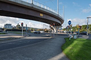
SANDYFORD VIADUCT
The flyover shown in my photographs is a significant piece of engineering on the Luas Green Line. Technically a viaduct, this large bridge structure serves a critical function. Its primary purpose is to create a grade-separated crossing, allowing the tram line to pass safely and efficiently over the multi-lane M50 motorway—Dublin's main orbital route—as well as the nearby Leopardstown Road/Torquay Road.
This structure was a key component of the Luas Green Line B1 extension, which extended the line south from its original terminus at Sandyford. The Central Park stop itself, which relies on this viaduct for its connection to the south, opened on 16 October 2010. This extension continued the line a further 7.5km south to Brides Glen in Cherrywood.
🗺️ Alignment and Route
The alignment of the Luas Green Line in this part of Dublin is heavily influenced by the transport corridors that preceded it.
Re-use of an Old Railway: Much of the Green Line's route from the city centre to Sandyford follows the original path of the Harcourt Street railway line, which operated from 1854 until its closure in 1958.
Modern Alignment: South of Sandyford, the line diverges from the old railway path. It runs through the Sandyford Business District before reaching the Central Park stop.
The Flyover's Role: Immediately after departing Central Park heading south, the tram ascends onto the viaduct to cross the M50. After clearing the motorway, it descends to run at-grade through the Glencairn, The Gallops, and Leopardstown Valley stops, weaving through residential areas that were largely developed in the 1990s and 2000s.
This structure was a key component of the Luas Green Line B1 extension, which extended the line south from its original terminus at Sandyford. The Central Park stop itself, which relies on this viaduct for its connection to the south, opened on 16 October 2010. This extension continued the line a further 7.5km south to Brides Glen in Cherrywood.
🗺️ Alignment and Route
The alignment of the Luas Green Line in this part of Dublin is heavily influenced by the transport corridors that preceded it.
Re-use of an Old Railway: Much of the Green Line's route from the city centre to Sandyford follows the original path of the Harcourt Street railway line, which operated from 1854 until its closure in 1958.
Modern Alignment: South of Sandyford, the line diverges from the old railway path. It runs through the Sandyford Business District before reaching the Central Park stop.
The Flyover's Role: Immediately after departing Central Park heading south, the tram ascends onto the viaduct to cross the M50. After clearing the motorway, it descends to run at-grade through the Glencairn, The Gallops, and Leopardstown Valley stops, weaving through residential areas that were largely developed in the 1990s and 2000s.

VIADUCT