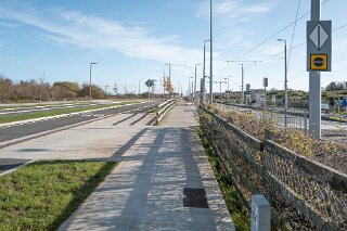
THE LAUGHANSTOWN TRAM STOP AND NEARBY PHOTOGRAPHED 2 NOVEMBER 2025
THE LAUGHANSTOWN TRAM STOP AND NEARBY [2 NOVEMBER 2025]
Changes at Laughanstown: A Guide to the New Development
A recent visit to the Laughanstown Luas stop reveals a significant transformation. The area is at the heart of one of Dublin's largest-ever development projects, raising questions about its history, present, and future.
Here is an overview of the key changes and answers to common questions about the area.
Laughanstown vs. Lehaunstown: What's in a Name?
It is easy to be confused by the two spellings, as both are used and have historical backing.
Official Tram Stop Name: The official name of the Luas Green Line stop is Laughanstown. This is the name used by Transport Infrastructure Ireland (TII) and on all official Luas maps and signage.
Historical/Variant Spelling: Lehaunstown is an older, anglicised version of the same name. The Irish name for the area is Baile an Locháin, which translates to "the town of the small lake." Over time, this was anglicised into various spellings, with both "Laughanstown" and "Lehaunstown" becoming common.
In short, while you will see "Lehaunstown" used in historical contexts and on some planning documents, Laughanstown is the official name for the tram stop itself.
The Cherrywood Strategic Development Zone (SDZ)
The massive construction site visible from the stop is the Cherrywood Strategic Development Zone (SDZ). This is a long-term, large-scale project planned to create an entirely new town.
The project, which is being built by several developers, spans a vast area. It is planned to include:
Over 10,000 new homes (a mix of apartments, duplexes, and houses)
A new town centre and several village centres
Retail spaces and offices
Numerous new parks (like Tully Park and Beckett Park, which are already open)
The new roads on-site, such as Grand Parade and Gun And Drum Hill, have been constructed to serve this new town. Grand Parade is the main thoroughfare running parallel to the Luas line, connecting the different parts of the development.
The Future of Lehaunstown Lane
It can be concerning to see that the old, rural Lehaunstown Lane has been blocked to through-traffic and fundamentally altered. However, its future is not to be replaced or removed, but rather to be integrated into the new urban landscape.
New Connections: The lane is being connected to the new road network. Planning documents show new roads being built to link Grand Parade with the alignment of the old Lehaunstown Lane.
Pedestrian & Cycle Focus: The Cherrywood plan places a very strong emphasis on walking routes and "greenways." The original, narrow path of Lehaunstown Lane is being retained in sections and repurposed as a key part of this pedestrian and cyclist network.
Ecological Corridor: In some new planning applications, the lane is specifically protected as an "ecological buffer," meaning its trees and hedgerows are being kept to create a green corridor within the new development.
So, while you can no longer drive down it as you once might have, the "ghost" of Lehaunstown Lane is being preserved as a central walking and cycling spine for the new community, connecting the new parks and residential areas.
Changes at Laughanstown: A Guide to the New Development
A recent visit to the Laughanstown Luas stop reveals a significant transformation. The area is at the heart of one of Dublin's largest-ever development projects, raising questions about its history, present, and future.
Here is an overview of the key changes and answers to common questions about the area.
Laughanstown vs. Lehaunstown: What's in a Name?
It is easy to be confused by the two spellings, as both are used and have historical backing.
Official Tram Stop Name: The official name of the Luas Green Line stop is Laughanstown. This is the name used by Transport Infrastructure Ireland (TII) and on all official Luas maps and signage.
Historical/Variant Spelling: Lehaunstown is an older, anglicised version of the same name. The Irish name for the area is Baile an Locháin, which translates to "the town of the small lake." Over time, this was anglicised into various spellings, with both "Laughanstown" and "Lehaunstown" becoming common.
In short, while you will see "Lehaunstown" used in historical contexts and on some planning documents, Laughanstown is the official name for the tram stop itself.
The Cherrywood Strategic Development Zone (SDZ)
The massive construction site visible from the stop is the Cherrywood Strategic Development Zone (SDZ). This is a long-term, large-scale project planned to create an entirely new town.
The project, which is being built by several developers, spans a vast area. It is planned to include:
Over 10,000 new homes (a mix of apartments, duplexes, and houses)
A new town centre and several village centres
Retail spaces and offices
Numerous new parks (like Tully Park and Beckett Park, which are already open)
The new roads on-site, such as Grand Parade and Gun And Drum Hill, have been constructed to serve this new town. Grand Parade is the main thoroughfare running parallel to the Luas line, connecting the different parts of the development.
The Future of Lehaunstown Lane
It can be concerning to see that the old, rural Lehaunstown Lane has been blocked to through-traffic and fundamentally altered. However, its future is not to be replaced or removed, but rather to be integrated into the new urban landscape.
New Connections: The lane is being connected to the new road network. Planning documents show new roads being built to link Grand Parade with the alignment of the old Lehaunstown Lane.
Pedestrian & Cycle Focus: The Cherrywood plan places a very strong emphasis on walking routes and "greenways." The original, narrow path of Lehaunstown Lane is being retained in sections and repurposed as a key part of this pedestrian and cyclist network.
Ecological Corridor: In some new planning applications, the lane is specifically protected as an "ecological buffer," meaning its trees and hedgerows are being kept to create a green corridor within the new development.
So, while you can no longer drive down it as you once might have, the "ghost" of Lehaunstown Lane is being preserved as a central walking and cycling spine for the new community, connecting the new parks and residential areas.


MAJOR CHANGE