WHY I WAS CONFUSED
TULLY PARK AND LEHAUNSTOWN LANE PLUS UNDEFINED RESIDENTIAL AREAS [SEPTEMBER 2023]
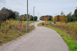
When I photographed the Cherrywood Area in September 2023 I found it very difficult to determine/name the exact locations and their extent/boundaries. So while I describe residential areas as being in Tully Park or along Lehaunstown Lane I could be inaccurate. I could not decide if Tully Church or the lane were actually part of Tully Park.
An Analytical Report on the Definition and Development of Cherrywood, Dublin 18: A Comparative Analysis (September 2023 – November 2025)
Section 1: Executive Summary of Findings
This report provides a comparative analysis of the Cherrywood Strategic Development Zone (SDZ), focusing on the areas of Tully Park, Lehaunstown Lane, and adjacent residential zones. It contrasts the landscape of September 2023 with that of November 2025.
The analysis reveals that the area photographed in September 2023 is incomparably more defined in November 2025. The spatial and toponymic confusion evident in 2023 was a valid observation of a specific "in-between" phase of large-scale, infrastructure-led development. By November 2025, this ambiguity has been resolved for this specific locality through the maturation of public amenities, the construction of new infrastructure, and the formal assignment of legal addresses.
Key findings are:
Resolution 1: Tully Park and Tully Church: The relationship between these two entities is no longer ambiguous. Tully Park is a mature 9-hectare flagship park. The National Monuments observed (Tully Church, Graveyard, and High Cross) are now its definitive, celebrated central heritage feature, a status confirmed by both official Dún Laoghaire-Rathdown County Council (DLRCoCo) descriptions and developer marketing.
Resolution 2: Lehaunstown Lane: The "lane" observed in 2023 has been radically transformed and functionally decommissioned as a primary vehicular through-road. As of June 2024, it has been replaced by the new Druid's Glen Road Phase 2. A "modal filter" now restricts the original lane's use to pedestrians and cyclists, preserving it as a greenway. Concurrently, a new "Lehaunstown Neighbourhood Road" (LNR) is being constructed to provide formal access to future developments.
Resolution 3: Residential Areas: The abstract "residential areas" under construction in 2023 are now formally defined residential neighbourhoods with legal addresses. The developer (Quintain, now rebranded as Evara) is marketing the area as "Cherrywood Village". Crucially, new, official street names such as "Tully Park View," "Tully Drive," "Tully Close," and "Tully Green" now exist. Sales for these properties began appearing on the Property Price Register (PPR) in late 2023 and have been assigned unique Eircodes (e.g., D18KV8X), integrating them fully into the national postal system. Developer site plans from 2024 and 2025 clearly delineate the precise spatial layout of these streets, definitively resolving the 2023 boundary questions.
Section 2: The 2023 Landscape: An Analysis of Spatial Ambiguity
The ambiguity surrounding the boundaries and identities of locations in September 2023 was a direct result of the area being in a highly transitional "messy middle" phase of development.
The Context of September 2023: A Landscape in Transition
In September 2023, an observer would have been standing at the nexus of major, overlapping construction and planning milestones, creating a disorienting landscape.
Newly Opened, Immature Parks: The three flagship parks for Cherrywood—Tully, Beckett, and Ticknick—were only officially opened in May 2023. In September 2023, just four months later, these parks would have been new, raw, and lacking the mature landscaping, clear signage, and established pathways required to fully integrate them into the surrounding environment.
A "Live" Planning Scheme: The overall plan for Cherrywood was still being actively amended at a high level. Amendment No. 8 to the Cherrywood Planning Scheme, concerning a review of building heights and density, was only approved by An Bord Pleanála in May 2023. This indicates that the foundational "rules" of the development were still settling even as the first elements were being built, a classic source of on-the-ground confusion.
Dueling Developer Visions: The observer was positioned at the intersection of two massive, parallel development projects managed by different entities:
Hines: Focussed on the "Cherrywood Town Centre" (TC), a 2.1 million-square-foot, €1 billion mixed-use development. In March 2023, Hines was actively presenting new landowner presentations for the Town Centre, indicating this core component was still in a detailed planning and review phase.
Quintain (now Evara): Responsible for "Cherrywood Village," a 65-acre, 1,300-home residential-led development. This was the project creating the houses and parks under observation.
Analysis of the 2023 Spatial Ambiguity
The specific points of confusion from 2023 are explainable by these overlapping development phases.
Observation 1: The Relationship Between Tully Church and Tully Park The initial uncertainty regarding whether Tully Church or the lane was part of Tully Park was logical. The official Cherrywood Planning Scheme did envision this integration. The plan included objectives to protect "Internal views... including Lehaunstown/Lehaunstown Park House and Tully/Tully Church" and for the park's design to be "appropriate to the tranquil character and setting of the cluster of national monuments at its centre".
However, in September 2023, an observer would have been experiencing a phasing disconnect. The "hard" infrastructure of the park (Phase 2 of which was funded by the Urban Regeneration and Development Fund) was delivered and opened. But the "soft" integration—the mature paths, wayfinding signage, landscaping, and public familiarity that would make its relationship with the church obvious—was not yet in place. An observer would have seen two distinct objects: an ancient church and a brand-new park that had not yet visually or functionally merged into the single, coherent entity that planners had envisioned.
Observation 2: The Identity of Residential Areas The description of "residential areas" as being "in Tully Park" or "along Lehaunstown Lane" was an accurate reflection of the area's ambiguous state at that time.
"Along Lehaunstown Lane": This was the old reality. Lehaunstown Lane was the existing, narrow rural artery. Construction access and site boundaries would have been referenced against it. Planning reports from 2023 and 2024 still referred to it as the main boundary for new developments.
"In Tully Park": This was the emerging commercial reality. The developer, Quintain, was actively using the brand-new park as the primary "amenity" to sell the adjacent houses, marketing them as a community of the park.
An observer at this time was standing in a "toponymic gap"—a period in urban development where the old, established place names (Lehaunstown Lane) are being rendered obsolete, but the new, legal, and formal place names (Tully Park View) have not yet been born or entered public consciousness. In September 2023, the homes were just "sites"; they were not yet "addresses." The observer was witnessing the gap between a developer's marketing concept ("Cherrywood Village") and a legal, postal reality that did not yet exist.
Section 3: The Cherrywood Landscape in November 2025: Definition and Identity
As of November 2025, the ambiguities of 2023 have been almost entirely resolved. The "in-between" phase for this specific district is over, and it has been replaced by a clearly defined, legible, and legally codified landscape.
Tully Park: A Defined Flagship Destination
Tully Park is no longer a "new" park; it is an established flagship destination. It is now a fully defined 9-hectare (22-acre) park. The query regarding the church is definitively resolved: the park's identity is now inseparable from the monuments. Marketing materials for the adjacent "Cherry Lane" and "Park Lane" developments explicitly state that residents can enjoy "national monuments such as Tully Church and Tully Cross, dating from 8th-11th centuries, carefully preserved and celebrated within the new facilities of the neighbourhood". Its status as a community hub is solidified by the presence of amenities such as the "Tully Park Cafe," which was used as a venue for a public drop-in event in August 2024.
The Radical Transformation of Lehaunstown Lane
The single, ambiguous "Lehaunstown Lane" of 2023 has been "unbundled" into four distinct, defined engineering and planning components. This is perhaps the most significant physical change to the area.
Decommissioning and Modal Filtering (June 2024): The completion of the "Druid's Glen Road Phase 2" project—a new 360m road and 3-span bridge that began construction in September 2023—was completed on 28 June 2024. This event triggered the closure of Lehaunstown Lane as a vehicular through-road. As of 27 June 2024, a "modal filter" was implemented, permanently restricting the lane to cyclists and pedestrians, with local vehicular access maintained for only the first 160m.
New Vehicular Arteries: The lane's old transport function has been formally replaced by two new, purpose-built roads:
Druid's Glen Road Phase 2: This is the new primary connection from the N11, designed to unlock the development lands.
Lehaunstown Neighbourhood Road (LNR): A new 380m road designed to link the Grand Parade with the (now-filtered) Lehaunstown Lane. Its specific purpose is to provide formal vehicular access to new DLRCoCo and Land Development Agency (LDA) housing developments. Public consultation for this new road ran from July to September 2024.
The Formal Greenway Network: The decommissioned lane is now formally part of the 5.0km "Cherrywood Green Routes Network". It is explicitly listed on masterplans as an "Exploration" point, alongside Tully Park and Tully Church, cementing its new role as a recreational and heritage amenity.
A New Development Site: "Lehaunstown Lane" is now also an address for major future development. In 2024 and 2025, the Land Development Agency (LDA) acquired a 4.73-hectare site at Lehaunstown Lane. This site is adjacent to land purchased by DLRCoCo, and combined, they are planned to deliver over 700 homes.
From "Residential Areas" to "Formal Addresses": The Proof of Definition
The most critical change is the formalisation of the residential zones. The "toponymic gap" has closed.
Commercial "Placemaking": The entire residential area is commercially branded "Cherrywood Village" by the developer Quintain/Evara. This "village" is now comprised of several clearly named neighbourhoods:
Cherry Lane: The first phase, with homes on sale since 2023.
Dolmen Lane: Launching in Autumn 2025.
Park Lane: Launching in Winter 2025, and explicitly marketed as "Overlooking Tully Park," further cementing the park's identity.
The Definitive "Ground Truth": New Streets and Eircodes: The abstract "areas" now have legal, postal, and searchable identities. The emergence of these addresses in official databases maps perfectly to the timeline since the September 2023 visit:
September 2023: An undefined construction site.
December 2023: The first sales of these new homes appear on the Property Price Register (PPR). Examples include 13 Tully Park View (sold 2023-12-14), 10 Tully Drive (sold 2023-12-14), and 11 Tully Park View (sold 2023-12-31).
2024-2025: These addresses are now commonplace in PPR data and are clearly delineated on developer site plans.
November 2025: The Eircode system, which assigns a unique identifier to every address, is fully populated. A search for "31 Tully Drive, Cherrywood, Dublin 18" reveals its unique Eircode: D18KV8X. The area is now an unambiguous, navigable, and defined part of the national postal infrastructure.
The New, Formal Streetscape
The developer site plans and Property Price Register data confirm the creation of a new, formal streetscape, replacing the undefined "areas" of 2023. Key new streets include:
Tully Park View: Part of the "Cherry Lane" neighbourhood, directly bordering the western edge of Tully Park.
Tully Drive: Forms the main "drive" through the new estate, running parallel to Tully Park View.
Tully Close: A cul-de-sac off Tully Drive, located within the new residential zone west of the park.
Tully Green: A street name within the residential area, likely named for a new green space within the estate.
Tully Road: A new road forming the southern boundary of the "Park Lane" development.
Gun and Drum Hill: A new road name that appears to be the main arterial route connecting the new estates.
Section 4: The Governance Framework: Understanding the Cherrywood SDZ
The "why" and "how" of the rapid transformation from ambiguity to definition is rooted in the area's unique governance model.
The "Blueprint": The Cherrywood SDZ Planning Scheme
The entire 360-hectare area is governed by the Cherrywood Strategic Development Zone (SDZ) Adapted Planning Scheme, which itself is a component of the DLRCoCo County Development Plan 2022-2028. An SDZ is a designation by the Government to fast-track development of strategic importance. DLRCoCo, as the Development Agency, creates a single "master-plan" (the scheme) that all developers must adhere to.
The "Infrastructure-Led" Model: The Source of the 2023 Confusion
This SDZ scheme is explicitly designed to "provide a strong degree of certainty regarding the phasing and delivery of new development, in tandem with the provision of essential infrastructure". This "infrastructure-led" model is the very source of the ambiguity experienced in 2023.
This model creates a "Certainty Paradox." For planners, it provides certainty that infrastructure will be in place. But for an on-the-ground observer, this model is inherently disorienting. It means that major amenities like parks, major new roads, and utilities are constructed first, often in the middle of empty fields, before the communities they are meant to serve have been built.
In September 2023, an observer was standing in the middle of this paradox: the infrastructure (Tully Park) was delivered, but the development (the houses) had not yet physically and conceptually connected to it to form a coherent "place." By November 2025, that connection is complete.
The boundaries that were difficult to determine are, in fact, rigidly defined by geospatial data (GeoJSON, KML, and SHP files) published by DLRCoCo and available on data.gov.ie. The "fuzziness" of 2023 was the gap between this digital "blueprint" and the physical world that was rapidly being built to match it. By November 2025, the physical world—with its new roads, house boundaries, and park edges—has finally caught up.
Section 5: Future Trajectory (The Next Wave of Change: 2025-2028)
The visit in November 2025 captures a moment of relative stability and definition for the "Cherrywood Village" residential district. The area immediately surrounding Tully Park is now a coherent, defined neighbourhood. However, data from 2024 and 2025 confirms that the broader Cherrywood SDZ is now entering the next phase of its infrastructure-led development.
The New "Lehaunstown Lane" Project: The next major development is now focussed back on Lehaunstown Lane itself. The Land Development Agency (LDA) and DLRCoCo have acquired adjacent sites at Lehaunstown Lane. This project will deliver 700+ new homes, with construction slated to begin in 2028. This future development is the explicit reason the new Lehaunstown Neighbourhood Road (LNR) is being constructed in 2024-2025.
The Town Centre Review: The other major developer, Hines, is concurrently in the process of a major review of its "Town Centre" plans with DLRCoCo, with submissions made in 2024. This involves the high-density, mixed-use retail and residential core of Cherrywood.
In conclusion, the "messy middle" is not gone. It has simply moved. The clarity and definition found at Tully Park in November 2025 is a product of a completed development phase. This clarity now contrasts with the next phase of ambiguity beginning just a few hundred metres away, as the cycle of infrastructure delivery (the new LNR) and large-scale site preparation (the new LDA/DLRCoCo lands) begins anew.
CONFUSION