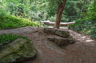
DEFORMED TREES AND EXPOSED ROOTS AT ST ANNE'S PARK
WHY ARE THE TREES DEFORMED AND THE ROOTS SO EXPOSED AT ST ANNE'S PARK [22 JULY 2026]
The wooded sections of St Anne’s Park in Raheny/Clontarf present an unusually gnarled, textured, and dramatic canopy. The distinctive features of these woods—from the twisted stems and exposed roots to the uneven ground—are the result of a deliberate 19th-century landscape design combined with coastal environmental conditions.
Why the Trees Are Deformed and Roots Exposed
Exposed Shallow Soil Overlaying Sand and Limestone:
The park sits directly adjacent to Dublin Bay, where a thin layer of topsoil overlays coastal sand, gravel, and limestone bedrock. Because the taproots cannot penetrate deep beneath the subsoil, the structural root plates expand horizontally near the surface to stabilise the weight of the canopy. Over decades, foot traffic, surface runoff, and wind action have eroded the thin topsoil, exposing massive, twisting lateral roots.
Severe Coastal Wind Pruning:
Positioned along the coast, the woodland is subject to constant onshore salt winds. This environmental stress forces asymmetric growth patterns—known as "flagging"—where branches warp, bend, and twist away from the prevailing seaward winds.
Historical Pruning and Lapsed Pollarding:
Many of the park’s mature specimens (such as those along the historic avenues) were subjected to pollarding—a technique where main upper branches are cut back decades ago to manage growth. Over time, these trees were allowed to regrow without ongoing management, resulting in heavy, gnarled limbs extending out from swollen, hollowed pruning points.
Why There Are So Many Mounds and Holes
Root-Plate Blowdowns (Pit-and-Mound Topography):
Due to the shallow root systems, high-wind storm events frequently cause mature trees to uproot entirely. When a tree falls, its root plate pulls up a vast mound of soil and turf, leaving an adjacent deep crater. Even after the fallen timber decomposes or is cleared away by park authorities, these elevated hummocks ("mounds") and steep depressions ("holes") remain permanently carved into the woodland floor.
Quarrying and Earthworks for Follies:
During the development of the estate in the 1800s, extensive earthmoving was undertaken. Soil and stone were excavated to construct artificial berms, shelter belts, man-made lakes, and embankments for the park's eleven historic stone follies along the Naniken River.
Active Wildlife Habitat:
The sandy, soft woodland floor makes the park an active habitat for burrowing wildlife. Extensive badger setts, fox earths, and rabbit warrens create networks of subterranean mounds and entry holes throughout the understory.
Are the Trees Special or Native?
The majority of the defining, aged woodland species in St Anne’s are non-native exotics carefully chosen for aesthetic grandeur and coastal resilience:
Holm Oak (Quercus ilex) & Monterey Pine (Pinus radiata): Evergreen broadleaves native to the Mediterranean and California respectively. They were deliberately planted in vast numbers to serve as a evergreen shelter belt against harsh marine winds.
Austrian Pine (Pinus nigra) & Beech (Fagus sylvatica): Form dramatic avenues and riverbank stands, valued for their structural grandeur.
Native & Self-Seeded Additions: Within the understory and along the Naniken River, native species such as Yew (Taxus baccata), Ash (Fraxinus excelsior), and Wych Elm (Ulmus glabra) grow alongside introduced species like Sycamore (Acer pseudoplatanus) and Horse Chestnut (Aesculus hippocatanum).
Is the Landscape Man-Made or Natural?
The landscape is overwhelmingly man-made and highly engineered, styled as an idealised 19th-century English parkland with romantic, Arcadian influences.
Beginning in 1835, the Guinness family (notably Sir Benjamin Lee Guinness and Lord Ardilaun) converted working agricultural demesne land into a formal private estate. They altered the natural topography by damming the Naniken River to create artificial lakes, planting grand ceremonial allées, constructing stone grottoes, and grading formal embankments. What appears today as a rugged, wild woodland is actually a heavily designed Victorian landscape that has naturally aged, weathered, and re-wilded over nearly two centuries.
The wooded sections of St Anne’s Park in Raheny/Clontarf present an unusually gnarled, textured, and dramatic canopy. The distinctive features of these woods—from the twisted stems and exposed roots to the uneven ground—are the result of a deliberate 19th-century landscape design combined with coastal environmental conditions.
Why the Trees Are Deformed and Roots Exposed
Exposed Shallow Soil Overlaying Sand and Limestone:
The park sits directly adjacent to Dublin Bay, where a thin layer of topsoil overlays coastal sand, gravel, and limestone bedrock. Because the taproots cannot penetrate deep beneath the subsoil, the structural root plates expand horizontally near the surface to stabilise the weight of the canopy. Over decades, foot traffic, surface runoff, and wind action have eroded the thin topsoil, exposing massive, twisting lateral roots.
Severe Coastal Wind Pruning:
Positioned along the coast, the woodland is subject to constant onshore salt winds. This environmental stress forces asymmetric growth patterns—known as "flagging"—where branches warp, bend, and twist away from the prevailing seaward winds.
Historical Pruning and Lapsed Pollarding:
Many of the park’s mature specimens (such as those along the historic avenues) were subjected to pollarding—a technique where main upper branches are cut back decades ago to manage growth. Over time, these trees were allowed to regrow without ongoing management, resulting in heavy, gnarled limbs extending out from swollen, hollowed pruning points.
Why There Are So Many Mounds and Holes
Root-Plate Blowdowns (Pit-and-Mound Topography):
Due to the shallow root systems, high-wind storm events frequently cause mature trees to uproot entirely. When a tree falls, its root plate pulls up a vast mound of soil and turf, leaving an adjacent deep crater. Even after the fallen timber decomposes or is cleared away by park authorities, these elevated hummocks ("mounds") and steep depressions ("holes") remain permanently carved into the woodland floor.
Quarrying and Earthworks for Follies:
During the development of the estate in the 1800s, extensive earthmoving was undertaken. Soil and stone were excavated to construct artificial berms, shelter belts, man-made lakes, and embankments for the park's eleven historic stone follies along the Naniken River.
Active Wildlife Habitat:
The sandy, soft woodland floor makes the park an active habitat for burrowing wildlife. Extensive badger setts, fox earths, and rabbit warrens create networks of subterranean mounds and entry holes throughout the understory.
Are the Trees Special or Native?
The majority of the defining, aged woodland species in St Anne’s are non-native exotics carefully chosen for aesthetic grandeur and coastal resilience:
Holm Oak (Quercus ilex) & Monterey Pine (Pinus radiata): Evergreen broadleaves native to the Mediterranean and California respectively. They were deliberately planted in vast numbers to serve as a evergreen shelter belt against harsh marine winds.
Austrian Pine (Pinus nigra) & Beech (Fagus sylvatica): Form dramatic avenues and riverbank stands, valued for their structural grandeur.
Native & Self-Seeded Additions: Within the understory and along the Naniken River, native species such as Yew (Taxus baccata), Ash (Fraxinus excelsior), and Wych Elm (Ulmus glabra) grow alongside introduced species like Sycamore (Acer pseudoplatanus) and Horse Chestnut (Aesculus hippocatanum).
Is the Landscape Man-Made or Natural?
The landscape is overwhelmingly man-made and highly engineered, styled as an idealised 19th-century English parkland with romantic, Arcadian influences.
Beginning in 1835, the Guinness family (notably Sir Benjamin Lee Guinness and Lord Ardilaun) converted working agricultural demesne land into a formal private estate. They altered the natural topography by damming the Naniken River to create artificial lakes, planting grand ceremonial allées, constructing stone grottoes, and grading formal embankments. What appears today as a rugged, wild woodland is actually a heavily designed Victorian landscape that has naturally aged, weathered, and re-wilded over nearly two centuries.
DEFORMED TREES AND SHALLOW ROOTS