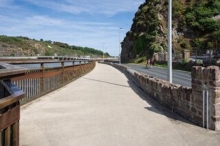
I THOUGHT THAT I WOULD EXPLORE THE WATERFORD GREENWAY
AFTER ABOUT FORTY FIVE MINUTES I ABANDONED THE PROJECT
At The beginning of the route, Grattan Quay, there is an interesting sculpture which the locals refer to as "The Chain". It is an eight-metre high, chain link piece incorporates a number of different images, including a 17th Century Tall Ship on top.
The sculpture, designed to celebrate the city’s rich maritime and industrial heritage, aims to visually enhance Grattan Quay itself and add to the area’s cultural heritage.
The piece, costing €60,000, was funded under the City Council’s Percent for Art Programme with a contribution from Diageo who are located on Grattan Quay. It was selected following extensive consultation with the artist, Denis O’Connor, who has previously worked on a number of public art pieces in both Ireland and Britain.
The idea of the chain links emerging from the ground and forming a river line suggested a type of renaissance for the city in terms of celebrating its rich maritime history.
Reassessing the Waterford Greenway: Route Planning, Footwork, and Photography Logistics
When exploring any urban centre or regional route, covering 20 to 25 kilometres a day on foot is standard practice. The key to making those long days sustainable—especially when laden with substantial camera bodies, high-grade glass, and accessories—is ensuring that transit works efficiently in at least one direction. There is little point in spending valuable energy walking an uninspiring access road only to face the prospect of retracing those exact steps.
During a recent photographic visit to Waterford, the plan was to explore the eastern approach of the renowned Waterford Greenway. Starting at the chain sculpture on Grattan Quay, the route headed west along Bilberry Road.
In hindsight, setting out on foot from that specific point was not the best idea.
The Problem with the Bilberry Approach on Foot
For the first two kilometres along Bilberry Road, the experience is entirely transitional. You find yourself navigating standard road pavements, negotiating traffic interfaces, rock cuttings, and peripheral commercial units before reaching the official Bilberry trailhead car park.
Carrying heavy gear along tarmac while waiting for the scenery to open up quickly revealed a logistical flaw: the greenway is strictly linear, stretching some 46 kilometres across the former railway corridor all the way to Dungarvan. It is not a circuit or a loop. Realising that pressing on would mean expending energy on utilitarian road margins—and then having to double back over the exact same terrain to return to the city centre—reversing course was the only logical decision.
A long-distance linear track requires a proper transit strategy rather than an impromptu out-and-back trek from the city quays.
How to Intercept the Greenway Better Next Time
Rather than walking out from the centre of Waterford, the proper approach is to use scheduled regional and local bus services from the Bus Station on The Quay to intercept key architectural, industrial, and landscape nodes along the line. This enables productive, one-way walks without wasting a single kilometre.
Carriganore and Mount Congreve (Riverside Run):
Taking a local bus out towards the SETU West Campus or Killoteran allows direct access to the scenic riverside section along the River Suir, cutting out the Bilberry road approach entirely. From there, a continuous 6 to 8-kilometre walk back towards the city takes in the river bends, historic lime kilns, and tranquil woodland fringes.
Kilmeadan Station:
Accessible via regional bus routes, this stop offers preserved narrow-gauge rolling stock, heritage railway infrastructure, and the nearby Woodstown settlement landscape, providing an ideal base for an eastward walk back towards Carriganore.
Kilmacthomas (The Industrial & Engineering Hub):
Boarding Bus Éireann Route 362 or Expressway Route 40 directly to Kilmacthomas brings you straight to the heart of the route’s finest railway architecture: the towering seven-arch stone viaduct, the deep Mahon River gorge, and the imposing stone structures of the restored Famine workhouse.
Durrow to Dungarvan Bay (Coastal & Tunnel Section):
Taking the coach to Durrow or Shanacool unlocks the dramatic 400-metre brick-lined Ballyvoyle Tunnel and the adjacent viaduct. From the tunnel exit, the path winds downhill with panoramic coastal views over Clonea Strand before concluding at Dungarvan Harbour—a magnificent 10 to 12-kilometre one-way stretch, ending with a relaxing coach journey back to Waterford.
The Takeaway
Walking 25 kilometres a day is immensely rewarding, but carrying serious photographic equipment demands smart logistical planning. Next time in Waterford, the strategy will be clear: bypass the road tarmac at Bilberry, catch the bus out to the viaducts, tunnels, and river bends, and let the route unfold as a continuous, one-way shoot.
At The beginning of the route, Grattan Quay, there is an interesting sculpture which the locals refer to as "The Chain". It is an eight-metre high, chain link piece incorporates a number of different images, including a 17th Century Tall Ship on top.
The sculpture, designed to celebrate the city’s rich maritime and industrial heritage, aims to visually enhance Grattan Quay itself and add to the area’s cultural heritage.
The piece, costing €60,000, was funded under the City Council’s Percent for Art Programme with a contribution from Diageo who are located on Grattan Quay. It was selected following extensive consultation with the artist, Denis O’Connor, who has previously worked on a number of public art pieces in both Ireland and Britain.
The idea of the chain links emerging from the ground and forming a river line suggested a type of renaissance for the city in terms of celebrating its rich maritime history.
Reassessing the Waterford Greenway: Route Planning, Footwork, and Photography Logistics
When exploring any urban centre or regional route, covering 20 to 25 kilometres a day on foot is standard practice. The key to making those long days sustainable—especially when laden with substantial camera bodies, high-grade glass, and accessories—is ensuring that transit works efficiently in at least one direction. There is little point in spending valuable energy walking an uninspiring access road only to face the prospect of retracing those exact steps.
During a recent photographic visit to Waterford, the plan was to explore the eastern approach of the renowned Waterford Greenway. Starting at the chain sculpture on Grattan Quay, the route headed west along Bilberry Road.
In hindsight, setting out on foot from that specific point was not the best idea.
The Problem with the Bilberry Approach on Foot
For the first two kilometres along Bilberry Road, the experience is entirely transitional. You find yourself navigating standard road pavements, negotiating traffic interfaces, rock cuttings, and peripheral commercial units before reaching the official Bilberry trailhead car park.
Carrying heavy gear along tarmac while waiting for the scenery to open up quickly revealed a logistical flaw: the greenway is strictly linear, stretching some 46 kilometres across the former railway corridor all the way to Dungarvan. It is not a circuit or a loop. Realising that pressing on would mean expending energy on utilitarian road margins—and then having to double back over the exact same terrain to return to the city centre—reversing course was the only logical decision.
A long-distance linear track requires a proper transit strategy rather than an impromptu out-and-back trek from the city quays.
How to Intercept the Greenway Better Next Time
Rather than walking out from the centre of Waterford, the proper approach is to use scheduled regional and local bus services from the Bus Station on The Quay to intercept key architectural, industrial, and landscape nodes along the line. This enables productive, one-way walks without wasting a single kilometre.
Carriganore and Mount Congreve (Riverside Run):
Taking a local bus out towards the SETU West Campus or Killoteran allows direct access to the scenic riverside section along the River Suir, cutting out the Bilberry road approach entirely. From there, a continuous 6 to 8-kilometre walk back towards the city takes in the river bends, historic lime kilns, and tranquil woodland fringes.
Kilmeadan Station:
Accessible via regional bus routes, this stop offers preserved narrow-gauge rolling stock, heritage railway infrastructure, and the nearby Woodstown settlement landscape, providing an ideal base for an eastward walk back towards Carriganore.
Kilmacthomas (The Industrial & Engineering Hub):
Boarding Bus Éireann Route 362 or Expressway Route 40 directly to Kilmacthomas brings you straight to the heart of the route’s finest railway architecture: the towering seven-arch stone viaduct, the deep Mahon River gorge, and the imposing stone structures of the restored Famine workhouse.
Durrow to Dungarvan Bay (Coastal & Tunnel Section):
Taking the coach to Durrow or Shanacool unlocks the dramatic 400-metre brick-lined Ballyvoyle Tunnel and the adjacent viaduct. From the tunnel exit, the path winds downhill with panoramic coastal views over Clonea Strand before concluding at Dungarvan Harbour—a magnificent 10 to 12-kilometre one-way stretch, ending with a relaxing coach journey back to Waterford.
The Takeaway
Walking 25 kilometres a day is immensely rewarding, but carrying serious photographic equipment demands smart logistical planning. Next time in Waterford, the strategy will be clear: bypass the road tarmac at Bilberry, catch the bus out to the viaducts, tunnels, and river bends, and let the route unfold as a continuous, one-way shoot.
THE GREENWAY