I USED A SONY A7RVI AND BOTH A SONY 24-105mm F4 AN A SONY 70-200MM F4
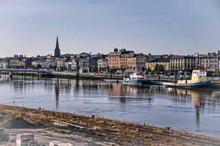
WATERFORD AS VIEWED FROM DOCK ROAD ON THE OPPOSITE SIDE OF THE RIVER SUIR [AUGUST 2026]
I used a Sony A7RVI with the FE 70-200mm F4 and the FE 25-104mm F4 lenses.
I had hoped that the new Railway Station and Pedestrian Bridge would be operational so I have already a room at the Granville Hotel, which can be seen in some of my photographs, for a week in August 2027. However, some have suggested that August would be to early as the project may still be incomplete until early 2028.
Standing along the curve of Dock Road, looking south across the tidal sweep of the River Suir, Waterford presents an intriguing study in contrasts. Directly opposite lies the bustling expanse of the South Quay—a panoramic frontage of Georgian architecture, lively shops, civic offices, and vibrant hospitality. Yet, on this northern bank, the perspective feels markedly detached from the heartbeat of Ireland’s oldest city.
For decades, thousands of residents who live on the north side—stretching through Ferrybank and spilling over the County Kilkenny border—have made their livelihoods and done their weekly shopping across the water.
Despite this daily economic and social connection, Northside communities have long endured an acute sense of isolation. Without access to private transport, crossing the Suir has historically been an exercise in frustration. The reliance on the singular bottleneck of Rice Bridge or infrequent public routes turned what should have been a five-minute hop into a prolonged commute, leaving non-drivers geographically close yet functionally cut off.
A Maritime Legacy Turned Brownfield
The North Bank was not always a peripheral bystander. In the nineteenth and twentieth centuries, this stretch was the industrial engine of the harbour, alive with the clank of cranes, steam whistles, and docking cargo vessels. As commercial shipping relocated downstream to Belview and rail freight patterns altered, the North Quays gradually emptied out.
What remained was an expanse of derelict brownfield land, abandoned warehouses, and overgrown rail sidings. Over the years, local amenities dwindled:
Commercial decline: Independent shops, pubs, and neighbourhood businesses shuttered, leaving vacant units along adjacent thoroughfares.
Service deficits: Basic community infrastructure struggled to gain traction, creating commercial "food and retail deserts" where residents had no choice but to cross the river for routine errands.
Economic stagnation: Several ambitious retail and commercial schemes stalled or collapsed before breaking ground, leaving parcels of prime waterfront idle for generations.
Reconnecting the Divide
The view from Dock Road is finally shifting from past industrial decline to long-awaited integration. With major infrastructural works—anchored by the new pedestrian, cycling, and public transport bridge alongside the relocated transport hub—the physical barrier between north and south is finally dissolving.
Waterford North Quays
For the residents on Dock Road and the wider north side, this connectivity promises more than just a pleasant riverside view. It offers direct, car-free access to Waterford’s urban centre, breathing much-needed life, investment, and community amenities back into a historically overlooked shoreline.
The River Suir Sustainable Transport Bridge is scheduled to open to the public in late 2026, while the new Waterford North Quays Transport Hub (relocated Plunkett Railway Station) is slated to become operational in early 2027 following rail signalling commissioning and system handovers.
Key Timelines
River Suir Sustainable Transport Bridge & South Plaza: Physical installation and deck alignment across the River Suir are completing in 2026, with architectural finishes (railings, lighting, surfacing) and bascule opening tests paving the way for public pedestrian and cycle access in Q4 2026.
New Railway Station / Multi-Modal Transport Hub: Main building and platform construction finishes in 2026. Final signalling, electrical integration, and track commissioning by Iarnród Éireann / Irish Rail will take place ahead of full service commencement in early 2027.
Waterford North Quays
Why the Project Has Taken So Long
The timeline reflects a mix of commercial false starts in the late 2010s followed by an exceptionally complex, multi-layered engineering scope:
Initial Developer & Funding Setbacks (Pre-2022): The North Quays Strategic Development Zone (SDZ) was originally tied to a private development agreement with Falcon Real Estate that collapsed in 2021 after deadlines for financial close were missed. Waterford City & County Council and the Irish Government restructured the approach by separating the core public infrastructure works from private commercial phases and securing over €170m in Urban Regeneration and Development Fund (URDF) and NTA funding before BAM was awarded the main construction contract in late 2022.
Massive Enabling & Marine Works: Before bridge spans or station tracks could be laid, contractors had to execute eight advance works packages. These included extensive railway rock cutting and cliff stabilisation along Plunkett Station, rerouting congested utility corridors under Dock Road, constructing deep cofferdams within a tidal Special Area of Conservation (SAC), and building a major new pumping station in Ferrybank.
Complex Movable Bridge Engineering: The 207-metre bridge includes a central opening bascule span to ensure the River Suir remains navigable for shipping and marine traffic. The steel deck sections required specialised fabrication in Ghent, Belgium, followed by sea-barge transport through the English Channel and Irish Sea, precise in-river placement onto marine piers, and complex mechanical/hydraulic commissioning.
Active Rail Corridor & Flood Defences: Shifting the railway station approximately 1 km west to the centre of the North Quays required maintaining uninterrupted train services into the existing Plunkett Station throughout construction. The project also encompasses approximately 1.6 km of new sheet-pile tidal flood defence walls and extensive track drainage to protect the rail corridor from rising sea levels and river surges.
I used a Sony A7RVI with the FE 70-200mm F4 and the FE 25-104mm F4 lenses.
I had hoped that the new Railway Station and Pedestrian Bridge would be operational so I have already a room at the Granville Hotel, which can be seen in some of my photographs, for a week in August 2027. However, some have suggested that August would be to early as the project may still be incomplete until early 2028.
Standing along the curve of Dock Road, looking south across the tidal sweep of the River Suir, Waterford presents an intriguing study in contrasts. Directly opposite lies the bustling expanse of the South Quay—a panoramic frontage of Georgian architecture, lively shops, civic offices, and vibrant hospitality. Yet, on this northern bank, the perspective feels markedly detached from the heartbeat of Ireland’s oldest city.
For decades, thousands of residents who live on the north side—stretching through Ferrybank and spilling over the County Kilkenny border—have made their livelihoods and done their weekly shopping across the water.
Despite this daily economic and social connection, Northside communities have long endured an acute sense of isolation. Without access to private transport, crossing the Suir has historically been an exercise in frustration. The reliance on the singular bottleneck of Rice Bridge or infrequent public routes turned what should have been a five-minute hop into a prolonged commute, leaving non-drivers geographically close yet functionally cut off.
A Maritime Legacy Turned Brownfield
The North Bank was not always a peripheral bystander. In the nineteenth and twentieth centuries, this stretch was the industrial engine of the harbour, alive with the clank of cranes, steam whistles, and docking cargo vessels. As commercial shipping relocated downstream to Belview and rail freight patterns altered, the North Quays gradually emptied out.
What remained was an expanse of derelict brownfield land, abandoned warehouses, and overgrown rail sidings. Over the years, local amenities dwindled:
Commercial decline: Independent shops, pubs, and neighbourhood businesses shuttered, leaving vacant units along adjacent thoroughfares.
Service deficits: Basic community infrastructure struggled to gain traction, creating commercial "food and retail deserts" where residents had no choice but to cross the river for routine errands.
Economic stagnation: Several ambitious retail and commercial schemes stalled or collapsed before breaking ground, leaving parcels of prime waterfront idle for generations.
Reconnecting the Divide
The view from Dock Road is finally shifting from past industrial decline to long-awaited integration. With major infrastructural works—anchored by the new pedestrian, cycling, and public transport bridge alongside the relocated transport hub—the physical barrier between north and south is finally dissolving.
Waterford North Quays
For the residents on Dock Road and the wider north side, this connectivity promises more than just a pleasant riverside view. It offers direct, car-free access to Waterford’s urban centre, breathing much-needed life, investment, and community amenities back into a historically overlooked shoreline.
The River Suir Sustainable Transport Bridge is scheduled to open to the public in late 2026, while the new Waterford North Quays Transport Hub (relocated Plunkett Railway Station) is slated to become operational in early 2027 following rail signalling commissioning and system handovers.
Key Timelines
River Suir Sustainable Transport Bridge & South Plaza: Physical installation and deck alignment across the River Suir are completing in 2026, with architectural finishes (railings, lighting, surfacing) and bascule opening tests paving the way for public pedestrian and cycle access in Q4 2026.
New Railway Station / Multi-Modal Transport Hub: Main building and platform construction finishes in 2026. Final signalling, electrical integration, and track commissioning by Iarnród Éireann / Irish Rail will take place ahead of full service commencement in early 2027.
Waterford North Quays
Why the Project Has Taken So Long
The timeline reflects a mix of commercial false starts in the late 2010s followed by an exceptionally complex, multi-layered engineering scope:
Initial Developer & Funding Setbacks (Pre-2022): The North Quays Strategic Development Zone (SDZ) was originally tied to a private development agreement with Falcon Real Estate that collapsed in 2021 after deadlines for financial close were missed. Waterford City & County Council and the Irish Government restructured the approach by separating the core public infrastructure works from private commercial phases and securing over €170m in Urban Regeneration and Development Fund (URDF) and NTA funding before BAM was awarded the main construction contract in late 2022.
Massive Enabling & Marine Works: Before bridge spans or station tracks could be laid, contractors had to execute eight advance works packages. These included extensive railway rock cutting and cliff stabilisation along Plunkett Station, rerouting congested utility corridors under Dock Road, constructing deep cofferdams within a tidal Special Area of Conservation (SAC), and building a major new pumping station in Ferrybank.
Complex Movable Bridge Engineering: The 207-metre bridge includes a central opening bascule span to ensure the River Suir remains navigable for shipping and marine traffic. The steel deck sections required specialised fabrication in Ghent, Belgium, followed by sea-barge transport through the English Channel and Irish Sea, precise in-river placement onto marine piers, and complex mechanical/hydraulic commissioning.
Active Rail Corridor & Flood Defences: Shifting the railway station approximately 1 km west to the centre of the North Quays required maintaining uninterrupted train services into the existing Plunkett Station throughout construction. The project also encompasses approximately 1.6 km of new sheet-pile tidal flood defence walls and extensive track drainage to protect the rail corridor from rising sea levels and river surges.
AS VIEWED FROM DOCK ROAD