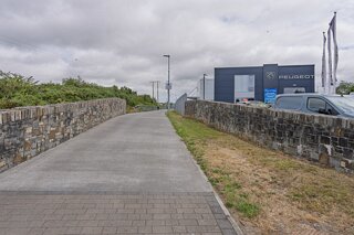
MY VISIT TO BALLYTRUNKLE AND MY STROLL ALONG THE RIVER WALK TOWARDS THE CITY CENTRE
When I visit a town or city I usually assign one day to exploring at random and today was one such day. I arrived at the Ursuline and Kilcohan area on the south-eastern side of Waterford City, specifically near Ursuline Court / Tramore Road where the R709 Inner Ring Road crosses St John’s River.
Location & Historical Background
Walking east along the Inner Ring Road past Ballytruckle and towards the Tramore Road roundabout brings you to a mixed-use commercial and residential district. The area features motor dealerships, modern apartment blocks, sports grounds (such as the Kingfisher Club and the Regional Sports Centre nearby), and housing developments named Ursuline Court. It is bounded directly by the meanders of St John’s River.
The History of the Ursuline Convent
The street names originate from the historic Ursuline Convent and Schools, founded here in the early 19th century:
1816 Foundation: Four sisters from the Ursuline Order in Thurles arrived in Waterford in 1816 to establish educational facilities for girls.
Elysium Estate: The sisters settled on the former Elysium estate along the river, providing both a boarding school for fee-paying pupils and free primary schooling for local children in what was then semi-rural countryside.
Architectural Legacy: Over the 19th century, substantial Gothic Revival additions were designed by architect George Goldie, including St Joseph’s House (1868) and the Chapel of the Sacred Heart (1874).
Modern Evolution: While the Ursuline educational tradition continues via St Angela’s Secondary School and St Ursula’s Primary School nearby, portions of the historic convent grounds have evolved into residential developments, community facilities, and retail spaces.
I found the area to be grim and unattractive - is this a common opinion?
While the official marketing and heritage descriptions focus on the historical convent roots and the concept of an ecological green corridor, visitors and locals often find that specific stretch awkward, stark, and uninviting.
Several urban planning and environmental factors contribute to that impression:
Car-Centric Planning: The junction where the R709 Inner Ring Road meets the Tramore Road was designed primarily for vehicle throughput rather than pedestrian appeal. Vast expanses of asphalt, large surface car parks, motor showrooms, and bulky commercial units create an environment stripped of human scale and street-level warmth.
Celtic Tiger Architectural Hangovers: Many of the multi-storey residential and commercial blocks around the Inner Ring Road and Ballytruckle date to the rapid construction boom of the late 1990s and 2000s. Rendered surfaces, utilitarian concrete finishes, and boxy designs often show weather staining and age poorly under Irish Atlantic rain, giving the built fabric a dreary, tired look.
Tidal Mud and Waterway Neglect: St John’s River is tidal and sluggish through this section. At low tide, it exposes muddy banks that catch urban debris, shopping trolleys, and litter. Historically, this stretch suffered severe water quality and dumping issues; although community clean-up groups have improved it, it lacks the manicured, scenic feel of formal riverside promenades.
Severance and Enclosure: High security fences around commercial backlots, blank boundary walls along housing estates, and concrete underpasses create a sense of being hemmed in between the backs of private properties rather than strolling through an open, welcoming parkland.
The river corridor only sheds that utilitarian, slightly gritty atmosphere as you get much closer to the historic centre—particularly once it enters the Victorian landscaping of the People’s Park and the stone quays of the Viking Triangle.
Leaving the quiet residential fringes of Ursuline Court behind, modern retail and traffic hum give way to an unexpected green corridor. Tucked right behind this bustling hub lies the trailhead of the St John’s Riverwalk — a tranquil, tree-lined path that follows the water all the way back into the Viking heart of Waterford City" This is discussed in another post.
Location & Historical Background
Walking east along the Inner Ring Road past Ballytruckle and towards the Tramore Road roundabout brings you to a mixed-use commercial and residential district. The area features motor dealerships, modern apartment blocks, sports grounds (such as the Kingfisher Club and the Regional Sports Centre nearby), and housing developments named Ursuline Court. It is bounded directly by the meanders of St John’s River.
The History of the Ursuline Convent
The street names originate from the historic Ursuline Convent and Schools, founded here in the early 19th century:
1816 Foundation: Four sisters from the Ursuline Order in Thurles arrived in Waterford in 1816 to establish educational facilities for girls.
Elysium Estate: The sisters settled on the former Elysium estate along the river, providing both a boarding school for fee-paying pupils and free primary schooling for local children in what was then semi-rural countryside.
Architectural Legacy: Over the 19th century, substantial Gothic Revival additions were designed by architect George Goldie, including St Joseph’s House (1868) and the Chapel of the Sacred Heart (1874).
Modern Evolution: While the Ursuline educational tradition continues via St Angela’s Secondary School and St Ursula’s Primary School nearby, portions of the historic convent grounds have evolved into residential developments, community facilities, and retail spaces.
I found the area to be grim and unattractive - is this a common opinion?
While the official marketing and heritage descriptions focus on the historical convent roots and the concept of an ecological green corridor, visitors and locals often find that specific stretch awkward, stark, and uninviting.
Several urban planning and environmental factors contribute to that impression:
Car-Centric Planning: The junction where the R709 Inner Ring Road meets the Tramore Road was designed primarily for vehicle throughput rather than pedestrian appeal. Vast expanses of asphalt, large surface car parks, motor showrooms, and bulky commercial units create an environment stripped of human scale and street-level warmth.
Celtic Tiger Architectural Hangovers: Many of the multi-storey residential and commercial blocks around the Inner Ring Road and Ballytruckle date to the rapid construction boom of the late 1990s and 2000s. Rendered surfaces, utilitarian concrete finishes, and boxy designs often show weather staining and age poorly under Irish Atlantic rain, giving the built fabric a dreary, tired look.
Tidal Mud and Waterway Neglect: St John’s River is tidal and sluggish through this section. At low tide, it exposes muddy banks that catch urban debris, shopping trolleys, and litter. Historically, this stretch suffered severe water quality and dumping issues; although community clean-up groups have improved it, it lacks the manicured, scenic feel of formal riverside promenades.
Severance and Enclosure: High security fences around commercial backlots, blank boundary walls along housing estates, and concrete underpasses create a sense of being hemmed in between the backs of private properties rather than strolling through an open, welcoming parkland.
The river corridor only sheds that utilitarian, slightly gritty atmosphere as you get much closer to the historic centre—particularly once it enters the Victorian landscaping of the People’s Park and the stone quays of the Viking Triangle.
Leaving the quiet residential fringes of Ursuline Court behind, modern retail and traffic hum give way to an unexpected green corridor. Tucked right behind this bustling hub lies the trailhead of the St John’s Riverwalk — a tranquil, tree-lined path that follows the water all the way back into the Viking heart of Waterford City" This is discussed in another post.
BALLYTRUNKLE WATERFORD